Buchholz geodata
Buchholz (Schleswig-Holstein) is a seat of a fourth-order administrative division; located in Germany in Europe/Berlin (GMT+2) time zone. With population of 1,128 people, there are 6770 cities with bigger population in this country. Compared to other cities in Germany, 92.5% of cities are located further ↓South; 61.9% of cities are located further →East and 85.4% of cities have higher elevation than Buchholz. Note1
Administrative division(s):
- Level 1: Schleswig-Holstein
- Level 3: Kreis Dithmarschen
- Level 4: Buchholz


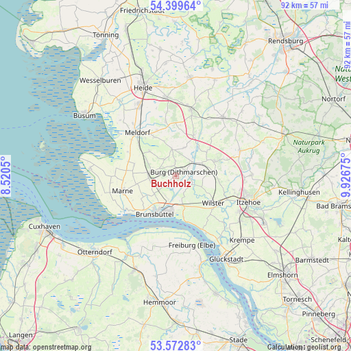
Buchholz GPS coordinates[2]
53° 59' 17.844" North, 9° 13' 25.032" East
| Map corner | latitude | longitude |
|---|---|---|
| Upper-left | 54.39964°, | 8.5205° |
| Center: | 53.98829°, | 9.22362° |
| Lower-right: | 53.57283°, | 9.92675° |
| Map W x H: | 91.9×91.9 km | = 57.1×57.1mi |
| max Lat: | 55.01917° ⇑7.5% North |
| Buchholz: | 53.98829° |
| min Lat: | ⇓92.5% South 47.40724° |
| min Long | Buchholz | max Long |
| 5.92978° | 9.22362° | 14.98853° |
| W 38.1%⇐ | ⇒61.9% E |
Elevation
Elevation of Buchholz is 34 m = 112 ft, and this is 215.1 m = 706 ft below average elevation for this country.
| Max E: |
1256 m = 4121 ft | 85.4% |
| Avg. | 249.1 m = 817 ft | |
| Buchholz | 34 m = 112 ft | |
Min E: |
-5 m = -16 ft | 14.6% |
See also: Germany elevation on elevation.city.
Geographical zone
Buchholz is located in North temperate zone (between Tropic of Cancer and the Arctic Circle). Distance of this North polar circle is 1398.2 km =868.8 mi to North.| Distance of | km | miles | from Buchholz |
|---|---|---|---|
| North Pole | 4004.1 | 2488 | to North |
| Arctic Circle | 1398.2 | 868.8 | to North |
| Tropic Cancer | 3397 | 2110.8 | to South |
| Equator | 6002.9 | 3730 | to South |


Nearby cities:
15 places around Buchholz: (largest is in red/bold)
• Aebtissinwisch
4.6 km =2.9 mi,  121°
121°
• Averlak
6 km =3.7 mi,  205°
205°
• Brickeln
3.2 km =2 mi,  11°
11°
• Burg
2.5 km =1.6 mi,  67°
67°
• Ecklak
5.1 km =3.2 mi,  146°
146°
• Eddelak
6.4 km =4 mi,  228°
228°
• Eggstedt
7.4 km =4.6 mi,  22°
22°
• Frestedt
5.7 km =3.5 mi,  332°
332°
• Großenrade
3.7 km =2.3 mi,  358°
358°
• Hochdonn
5.5 km =3.4 mi,  38°
38°
• Kuden
3.6 km =2.2 mi, 227°
• Kudensee
6.1 km =3.8 mi,  184°
184°
• Quickborn
2.7 km =1.7 mi,  338°
338°
• Sankt Michaelisdonn
7 km =4.3 mi,  265°
265°
• Süderhastedt
6.9 km =4.3 mi,  351°
351°
Sources, notices
• [Note1] Compared only with cities in Germany existing in our database
• [Src1] Map data: © OpenStreetMap contributors (CC-BY-SA)
• [Src2] Other city data from geonames.org with taken over terms of usage.
• [Src3] Geographical zone / Annual Mean Temperature by Robert A. Rohde @ Wikipedia
