Süderhastedt geodata
Süderhastedt (Schleswig-Holstein) is a seat of a fourth-order administrative division; located in Germany in Europe/Berlin (GMT+2) time zone. With population of 860 people, there are 7664 cities with bigger population in this country. Compared to other cities in Germany, 93.3% of cities are located further ↓South; 62.2% of cities are located further →East and 93.5% of cities have higher elevation than Süderhastedt. Note1
Administrative division(s):
- Level 1: Schleswig-Holstein
- Level 3: Kreis Dithmarschen
- Level 4: Süderhastedt


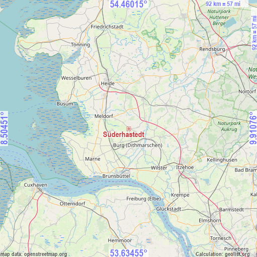
Süderhastedt GPS coordinates[2]
54° 2' 57.84" North, 9° 12' 27.468" East
| Map corner | latitude | longitude |
|---|---|---|
| Upper-left | 54.46015°, | 8.50451° |
| Center: | 54.0494°, | 9.20763° |
| Lower-right: | 53.63455°, | 9.91076° |
| Map W x H: | 91.8×91.8 km | = 57×57mi |
| max Lat: | 55.01917° ⇑6.7% North |
| Süderhastedt: | 54.0494° |
| min Lat: | ⇓93.3% South 47.40724° |
| min Long | Süderhastedt | max Long |
| 5.92978° | 9.20763° | 14.98853° |
| W 37.8%⇐ | ⇒62.2% E |
Elevation
Elevation of Süderhastedt is 12 m = 39 ft, and this is 237.1 m = 778 ft below average elevation for this country.
| Max E: |
1256 m = 4121 ft | 93.5% |
| Avg. | 249.1 m = 817 ft | |
| Süderhastedt | 12 m = 39 ft | |
Min E: |
-5 m = -16 ft | 6.5% |
See also: Germany elevation on elevation.city.
Geographical zone
Süderhastedt is located in North temperate zone (between Tropic of Cancer and the Arctic Circle). Distance of this North polar circle is 1391.4 km =864.6 mi to North.| Distance of | km | miles | from Süderhastedt |
|---|---|---|---|
| North Pole | 3997.3 | 2483.8 | to North |
| Arctic Circle | 1391.4 | 864.6 | to North |
| Tropic Cancer | 3403.8 | 2115 | to South |
| Equator | 6009.7 | 3734.3 | to South |


Nearby cities:
15 places around Süderhastedt: (largest is in red/bold)
• Bargenstedt
6.8 km =4.2 mi,  326°
326°
• Brickeln
4 km =2.5 mi,  155°
155°
• Buchholz
6.9 km =4.3 mi,  171°
171°
• Burg
6.7 km =4.2 mi,  150°
150°
• Eggstedt
3.9 km =2.4 mi,  89°
89°
• Frestedt
2.4 km =1.5 mi,  221°
221°
• Großenrade
3.3 km =2.1 mi, 162°
• Gudendorf
7.1 km =4.4 mi,  246°
246°
• Hochdonn
5.1 km =3.2 mi,  119°
119°
• Krumstedt
2.5 km =1.6 mi,  320°
320°
• Nindorf
7 km =4.3 mi,  302°
302°
• Quickborn
4.3 km =2.7 mi,  178°
178°
• Schafstedt
7.1 km =4.4 mi,  57°
57°
• Tensbüttel-Röst
5.9 km =3.7 mi,  16°
16°
• Windbergen
5.9 km =3.7 mi,  270°
270°
Sources, notices
• [Note1] Compared only with cities in Germany existing in our database
• [Src1] Map data: © OpenStreetMap contributors (CC-BY-SA)
• [Src2] Other city data from geonames.org with taken over terms of usage.
• [Src3] Geographical zone / Annual Mean Temperature by Robert A. Rohde @ Wikipedia
