Waal geodata
Waal (Bavaria) is a populated place; located in Germany in Europe/Berlin (GMT+2) time zone. With population of 2,152 people, there are 4866 cities with bigger population in this country. Compared to other cities in Germany, 95.6% of cities are located further ↑North; 63.7% of cities are located further ←West and 96.1% of cities have lower elevation than Waal. Note1
Administrative division(s):
- Level 1: Bavaria
- Level 2: Swabia
- Level 3: Landkreis Ostallgäu
- Level 4: Waal, Markt


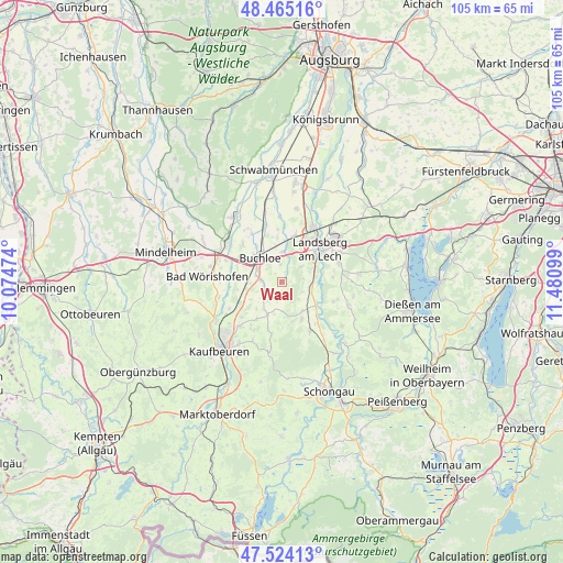
Waal GPS coordinates[2]
47° 59' 48.444" North, 10° 46' 40.296" East
| Map corner | latitude | longitude |
|---|---|---|
| Upper-left | 48.46516°, | 10.07474° |
| Center: | 47.99679°, | 10.77786° |
| Lower-right: | 47.52413°, | 11.48099° |
| Map W x H: | 104.6×104.6 km | = 65×65mi |
| max Lat: | 55.01917° ⇑95.6% North |
| Waal: | 47.99679° |
| min Lat: | ⇓4.4% South 47.40724° |
| min Long | Waal | max Long |
| 5.92978° | 10.77786° | 14.98853° |
| W 63.7%⇐ | ⇒36.3% E |
Elevation
Elevation of Waal is 633 m = 2077 ft, and this is 383.9 m = 1260 ft above average elevation for this country.
| Max E: |
1256 m = 4121 ft | 3.9% |
| Waal | 633 m 2077 ft | |
| Avg. | 249.1 m = 817 ft | |
Min E: |
-5 m = -16 ft | 96.1% |
See also: Germany elevation on elevation.city.
Geographical zone
Waal is located in North temperate zone (between Tropic of Cancer and the Arctic Circle). Distance of this North polar circle is 2064.4 km =1282.8 mi to North.| Distance of | km | miles | from Waal |
|---|---|---|---|
| North Pole | 4670.3 | 2902 | to North |
| Arctic Circle | 2064.4 | 1282.8 | to North |
| Tropic Cancer | 2730.8 | 1696.8 | to South |
| Equator | 5336.7 | 3316.1 | to South |


Nearby cities:
15 places around Waal: (largest is in red/bold)
• Amberg
10.5 km =6.5 mi,  317°
317°
• Buchloe
5.9 km =3.7 mi, 319°
• Denklingen
10.4 km =6.5 mi,  148°
148°
• Jengen
3.9 km =2.4 mi,  274°
274°
• Lamerdingen
11 km =6.8 mi,  345°
345°
• Landsberg am Lech
9.7 km =6 mi,  53°
53°
• Oberostendorf
6.5 km =4 mi,  203°
203°
• Pürgen
11.2 km =7 mi,  73°
73°
• Rieden
10.8 km =6.7 mi,  241°
241°
• Schwifting
12.4 km =7.7 mi,  64°
64°
• Türkheim
12.6 km =7.8 mi,  306°
306°
• Unterdießen
4.4 km =2.7 mi,  109°
109°
• Vilgertshofen
11.6 km =7.2 mi,  116°
116°
• Westendorf
8.4 km =5.2 mi,  212°
212°
• Wiedergeltingen
9.1 km =5.7 mi,  301°
301°
Sources, notices
• [Note1] Compared only with cities in Germany existing in our database
• [Src1] Map data: © OpenStreetMap contributors (CC-BY-SA)
• [Src2] Other city data from geonames.org with taken over terms of usage.
• [Src3] Geographical zone / Annual Mean Temperature by Robert A. Rohde @ Wikipedia
