Mittenwalde geodata
Mittenwalde (Brandenburg) is a seat of a fourth-order administrative division; located in Germany in Europe/Berlin (GMT+2) time zone. With population of 488 people, there are 9425 cities with bigger population in this country. Compared to other cities in Germany, 82.7% of cities are located further ↓South; 96.7% of cities are located further ←West and 72.6% of cities have higher elevation than Mittenwalde. Note1


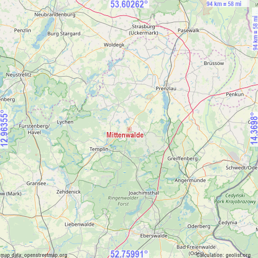
Mittenwalde GPS coordinates[2]
53° 10' 59.988" North, 13° 40' 0.012" East
| Map corner | latitude | longitude |
|---|---|---|
| Upper-left | 53.60262°, | 12.96355° |
| Center: | 53.18333°, | 13.66667° |
| Lower-right: | 52.75991°, | 14.3698° |
| Map W x H: | 93.7×93.7 km | = 58.2×58.2mi |
| max Lat: | 55.01917° ⇑17.3% North |
| Mittenwalde: | 53.18333° |
| min Lat: | ⇓82.7% South 47.40724° |
| min Long | Mittenwalde | max Long |
| 5.92978° | 13.66667° | 14.98853° |
| W 96.7%⇐ | ⇒3.3% E |
Elevation
Elevation of Mittenwalde is 74 m = 243 ft, and this is 175.1 m = 574 ft below average elevation for this country.
| Max E: |
1256 m = 4121 ft | 72.6% |
| Avg. | 249.1 m = 817 ft | |
| Mittenwalde | 74 m = 243 ft | |
Min E: |
-5 m = -16 ft | 27.4% |
See also: Germany elevation on elevation.city.
Geographical zone
Mittenwalde is located in North temperate zone (between Tropic of Cancer and the Arctic Circle). Distance of this North polar circle is 1487.7 km =924.4 mi to North.| Distance of | km | miles | from Mittenwalde |
|---|---|---|---|
| North Pole | 4093.6 | 2543.6 | to North |
| Arctic Circle | 1487.7 | 924.4 | to North |
| Tropic Cancer | 3307.5 | 2055.2 | to South |
| Equator | 5913.4 | 3674.4 | to South |


Nearby cities:
15 places around Mittenwalde: (largest is in red/bold)
• Althüttendorf
26.3 km =16.3 mi,  159°
159°
• Angermünde
29 km =18 mi,  130°
130°
• Friedrichswalde
17.3 km =10.7 mi,  171°
171°
• Gerswalde
5.7 km =3.5 mi,  105°
105°
• Gramzow
22.9 km =14.2 mi,  81°
81°
• Grünow
24 km =14.9 mi,  51°
51°
• Göritz
29.8 km =18.5 mi,  33°
33°
• Joachimsthal
23.3 km =14.5 mi, 167°
• Lychen
23.7 km =14.7 mi,  277°
277°
• Milmersdorf
8.1 km =5 mi,  191°
191°
• Passow
30.2 km =18.8 mi,  98°
98°
• Prenzlau
19.7 km =12.2 mi,  41°
41°
• Schenkenberg
27.8 km =17.3 mi, 42°
• Templin
13.1 km =8.1 mi,  236°
236°
• Zichow
24.8 km =15.4 mi,  88°
88°
Sources, notices
• [Note1] Compared only with cities in Germany existing in our database
• [Src1] Map data: © OpenStreetMap contributors (CC-BY-SA)
• [Src2] Other city data from geonames.org with taken over terms of usage.
• [Src3] Geographical zone / Annual Mean Temperature by Robert A. Rohde @ Wikipedia
