Pottenstein geodata
Pottenstein (Bavaria) is a populated place; located in Germany in Europe/Berlin (GMT+2) time zone. With population of 5,501 people, there are 2625 cities with bigger population in this country. Compared to other cities in Germany, 69.6% of cities are located further ↑North; 72.8% of cities are located further ←West and 70.5% of cities have lower elevation than Pottenstein. Note1
Administrative division(s):
- Level 1: Bavaria
- Level 2: Upper Franconia
- Level 3: Landkreis Bayreuth
- Level 4: Pottenstein


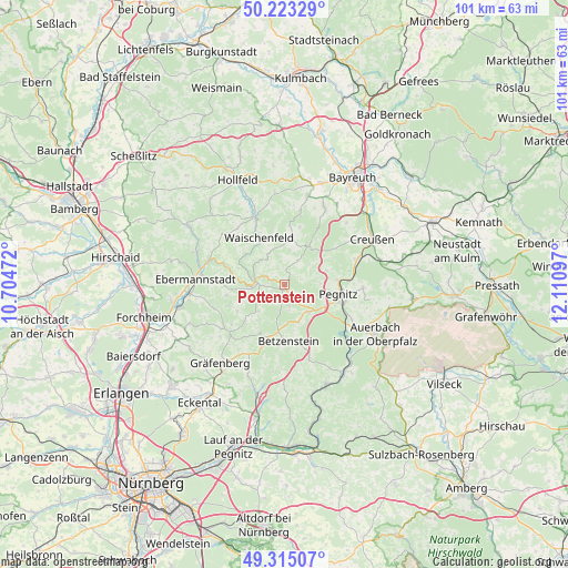
Pottenstein GPS coordinates[2]
49° 46' 16.716" North, 11° 24' 28.224" East
| Map corner | latitude | longitude |
|---|---|---|
| Upper-left | 50.22329°, | 10.70472° |
| Center: | 49.77131°, | 11.40784° |
| Lower-right: | 49.31507°, | 12.11097° |
| Map W x H: | 101×101 km | = 62.8×62.8mi |
| max Lat: | 55.01917° ⇑69.6% North |
| Pottenstein: | 49.77131° |
| min Lat: | ⇓30.4% South 47.40724° |
| min Long | Pottenstein | max Long |
| 5.92978° | 11.40784° | 14.98853° |
| W 72.8%⇐ | ⇒27.2% E |
Elevation
Elevation of Pottenstein is 362 m = 1188 ft, and this is 112.9 m = 370 ft above average elevation for this country.
| Max E: |
1256 m = 4121 ft | 29.5% |
| Pottenstein | 362 m 1188 ft | |
| Avg. | 249.1 m = 817 ft | |
Min E: |
-5 m = -16 ft | 70.5% |
See also: Germany elevation on elevation.city.
Geographical zone
Pottenstein is located in North temperate zone (between Tropic of Cancer and the Arctic Circle). Distance of this North polar circle is 1867.1 km =1160.2 mi to North.| Distance of | km | miles | from Pottenstein |
|---|---|---|---|
| North Pole | 4473 | 2779.4 | to North |
| Arctic Circle | 1867.1 | 1160.2 | to North |
| Tropic Cancer | 2928.1 | 1819.4 | to South |
| Equator | 5534.1 | 3438.7 | to South |


Nearby cities:
15 places around Pottenstein: (largest is in red/bold)
• Ebermannstadt
16.3 km =10.1 mi,  274°
274°
• Egloffstein
13.3 km =8.3 mi,  234°
234°
• Gesees
16.9 km =10.5 mi,  32°
32°
• Glashütten
13.2 km =8.2 mi,  12°
12°
• Gößweinstein
5 km =3.1 mi, 267°
• Haag
15.5 km =9.6 mi,  44°
44°
• Hiltpoltstein
13.7 km =8.5 mi,  206°
206°
• Mistelgau
16.3 km =10.1 mi, 14°
• Obertrubach
9 km =5.6 mi, 207°
• Pegnitz
9.9 km =6.2 mi,  102°
102°
• Plankenfels
13.6 km =8.5 mi,  336°
336°
• Pretzfeld
16.9 km =10.5 mi,  263°
263°
• Schnabelwaid
13.4 km =8.3 mi,  70°
70°
• Unterleinleiter
16.7 km =10.4 mi,  290°
290°
• Waischenfeld
9.4 km =5.8 mi,  332°
332°
Sources, notices
• [Note1] Compared only with cities in Germany existing in our database
• [Src1] Map data: © OpenStreetMap contributors (CC-BY-SA)
• [Src2] Other city data from geonames.org with taken over terms of usage.
• [Src3] Geographical zone / Annual Mean Temperature by Robert A. Rohde @ Wikipedia
