Glashütten geodata
Glashütten (Bavaria) is a seat of a fourth-order administrative division; located in Germany in Europe/Berlin (GMT+2) time zone. With population of 1,569 people, there are 5744 cities with bigger population in this country. Compared to other cities in Germany, 66.8% of cities are located further ↑North; 73.4% of cities are located further ←West and 78.5% of cities have lower elevation than Glashütten. Note1
Administrative division(s):
- Level 1: Bavaria
- Level 2: Upper Franconia
- Level 3: Landkreis Bayreuth
- Level 4: Glashütten


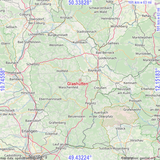
Glashütten GPS coordinates[2]
49° 53' 14.604" North, 11° 26' 55.32" East
| Map corner | latitude | longitude |
|---|---|---|
| Upper-left | 50.33828°, | 10.74558° |
| Center: | 49.88739°, | 11.4487° |
| Lower-right: | 49.43224°, | 12.15183° |
| Map W x H: | 100.7×100.7 km | = 62.6×62.6mi |
| max Lat: | 55.01917° ⇑66.8% North |
| Glashütten: | 49.88739° |
| min Lat: | ⇓33.2% South 47.40724° |
| min Long | Glashütten | max Long |
| 5.92978° | 11.4487° | 14.98853° |
| W 73.4%⇐ | ⇒26.6% E |
Elevation
Elevation of Glashütten is 423 m = 1388 ft, and this is 173.9 m = 571 ft above average elevation for this country.
| Max E: |
1256 m = 4121 ft | 21.5% |
| Glashütten | 423 m 1388 ft | |
| Avg. | 249.1 m = 817 ft | |
Min E: |
-5 m = -16 ft | 78.5% |
See also: Germany elevation on elevation.city.
Geographical zone
Glashütten is located in North temperate zone (between Tropic of Cancer and the Arctic Circle). Distance of this North polar circle is 1854.2 km =1152.1 mi to North.| Distance of | km | miles | from Glashütten |
|---|---|---|---|
| North Pole | 4460.1 | 2771.4 | to North |
| Arctic Circle | 1854.2 | 1152.1 | to North |
| Tropic Cancer | 2941 | 1827.5 | to South |
| Equator | 5547 | 3446.7 | to South |


Nearby cities:
15 places around Glashütten: (largest is in red/bold)
• Bayreuth
11.5 km =7.1 mi,  54°
54°
• Creußen
13.6 km =8.5 mi,  110°
110°
• Eckersdorf
6.3 km =3.9 mi,  32°
32°
• Emtmannsberg
14 km =8.7 mi,  87°
87°
• Gesees
6.2 km =3.9 mi,  76°
76°
• Haag
8.3 km =5.2 mi,  103°
103°
• Heinersreuth
10.7 km =6.6 mi, 34°
• Hollfeld
12.6 km =7.8 mi,  296°
296°
• Mistelbach
5.4 km =3.4 mi,  58°
58°
• Mistelgau
3.1 km =1.9 mi,  23°
23°
• Plankenfels
8.3 km =5.2 mi,  266°
266°
• Pottenstein
13.2 km =8.2 mi,  192°
192°
• Schnabelwaid
12.7 km =7.9 mi,  131°
131°
• Waischenfeld
8.5 km =5.3 mi,  237°
237°
• Wonsees
14.5 km =9 mi,  312°
312°
Sources, notices
• [Note1] Compared only with cities in Germany existing in our database
• [Src1] Map data: © OpenStreetMap contributors (CC-BY-SA)
• [Src2] Other city data from geonames.org with taken over terms of usage.
• [Src3] Geographical zone / Annual Mean Temperature by Robert A. Rohde @ Wikipedia
