Mistelgau geodata
Mistelgau (Bavaria) is a seat of a fourth-order administrative division; located in Germany in Europe/Berlin (GMT+2) time zone. With population of 3,858 people, there are 3376 cities with bigger population in this country. Compared to other cities in Germany, 66.1% of cities are located further ↑North; 73.7% of cities are located further ←West and 80.8% of cities have lower elevation than Mistelgau. Note1
Administrative division(s):
- Level 1: Bavaria
- Level 2: Upper Franconia
- Level 3: Landkreis Bayreuth
- Level 4: Mistelgau


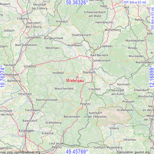
Mistelgau GPS coordinates[2]
49° 54' 45.36" North, 11° 27' 57.096" East
| Map corner | latitude | longitude |
|---|---|---|
| Upper-left | 50.36326°, | 10.76274° |
| Center: | 49.9126°, | 11.46586° |
| Lower-right: | 49.45769°, | 12.16899° |
| Map W x H: | 100.7×100.7 km | = 62.6×62.6mi |
| max Lat: | 55.01917° ⇑66.1% North |
| Mistelgau: | 49.9126° |
| min Lat: | ⇓33.9% South 47.40724° |
| min Long | Mistelgau | max Long |
| 5.92978° | 11.46586° | 14.98853° |
| W 73.7%⇐ | ⇒26.3% E |
Elevation
Elevation of Mistelgau is 438 m = 1437 ft, and this is 188.9 m = 620 ft above average elevation for this country.
| Max E: |
1256 m = 4121 ft | 19.2% |
| Mistelgau | 438 m 1437 ft | |
| Avg. | 249.1 m = 817 ft | |
Min E: |
-5 m = -16 ft | 80.8% |
See also: Germany elevation on elevation.city.
Geographical zone
Mistelgau is located in North temperate zone (between Tropic of Cancer and the Arctic Circle). Distance of this North polar circle is 1851.4 km =1150.4 mi to North.| Distance of | km | miles | from Mistelgau |
|---|---|---|---|
| North Pole | 4457.3 | 2769.6 | to North |
| Arctic Circle | 1851.4 | 1150.4 | to North |
| Tropic Cancer | 2943.8 | 1829.2 | to South |
| Equator | 5549.8 | 3448.5 | to South |


Nearby cities:
15 places around Mistelgau: (largest is in red/bold)
• Bayreuth
9 km =5.6 mi,  64°
64°
• Bindlach
13.1 km =8.1 mi,  54°
54°
• Eckersdorf
3.3 km =2.1 mi,  41°
41°
• Emtmannsberg
13 km =8.1 mi,  99°
99°
• Gesees
5 km =3.1 mi,  106°
106°
• Glashütten
3.1 km =1.9 mi,  203°
203°
• Haag
8.3 km =5.2 mi,  124°
124°
• Heinersreuth
7.7 km =4.8 mi, 38°
• Hollfeld
12.8 km =8 mi,  282°
282°
• Mistelbach
3.3 km =2.1 mi,  90°
90°
• Neudrossenfeld
11.8 km =7.3 mi,  11°
11°
• Neunkirchen am Main
13.1 km =8.1 mi,  84°
84°
• Plankenfels
10 km =6.2 mi,  251°
251°
• Thurnau
13.6 km =8.5 mi,  337°
337°
• Waischenfeld
11.2 km =7 mi,  228°
228°
Sources, notices
• [Note1] Compared only with cities in Germany existing in our database
• [Src1] Map data: © OpenStreetMap contributors (CC-BY-SA)
• [Src2] Other city data from geonames.org with taken over terms of usage.
• [Src3] Geographical zone / Annual Mean Temperature by Robert A. Rohde @ Wikipedia
