Pegnitz geodata
Pegnitz (Bavaria) is a populated place; located in Germany in Europe/Berlin (GMT+2) time zone. With population of 14,279 people, there are 1110 cities with bigger population in this country. Compared to other cities in Germany, 70.1% of cities are located further ↑North; 74.9% of cities are located further ←West and 80.1% of cities have lower elevation than Pegnitz. Note1
Administrative division(s):
- Level 1: Bavaria
- Level 2: Upper Franconia
- Level 3: Landkreis Bayreuth
- Level 4: Pegnitz


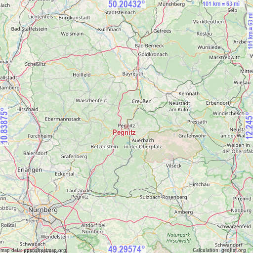
Pegnitz GPS coordinates[2]
49° 45' 7.776" North, 11° 32' 30.732" East
| Map corner | latitude | longitude |
|---|---|---|
| Upper-left | 50.20432°, | 10.83875° |
| Center: | 49.75216°, | 11.54187° |
| Lower-right: | 49.29574°, | 12.245° |
| Map W x H: | 101×101 km | = 62.8×62.8mi |
| max Lat: | 55.01917° ⇑70.1% North |
| Pegnitz: | 49.75216° |
| min Lat: | ⇓29.9% South 47.40724° |
| min Long | Pegnitz | max Long |
| 5.92978° | 11.54187° | 14.98853° |
| W 74.9%⇐ | ⇒25.1% E |
Elevation
Elevation of Pegnitz is 433 m = 1421 ft, and this is 183.9 m = 603 ft above average elevation for this country.
| Max E: |
1256 m = 4121 ft | 19.9% |
| Pegnitz | 433 m 1421 ft | |
| Avg. | 249.1 m = 817 ft | |
Min E: |
-5 m = -16 ft | 80.1% |
See also: Germany elevation on elevation.city.
Geographical zone
Pegnitz is located in North temperate zone (between Tropic of Cancer and the Arctic Circle). Distance of this North polar circle is 1869.3 km =1161.5 mi to North.| Distance of | km | miles | from Pegnitz |
|---|---|---|---|
| North Pole | 4475.1 | 2780.7 | to North |
| Arctic Circle | 1869.3 | 1161.5 | to North |
| Tropic Cancer | 2926 | 1818.1 | to South |
| Equator | 5531.9 | 3437.4 | to South |


Nearby cities:
15 places around Pegnitz: (largest is in red/bold)
• Auerbach
9.4 km =5.8 mi,  135°
135°
• Creußen
12 km =7.5 mi,  30°
30°
• Gesees
16.4 km =10.2 mi,  357°
357°
• Glashütten
16.5 km =10.3 mi,  336°
336°
• Gößweinstein
14.7 km =9.1 mi,  277°
277°
• Haag
13.2 km =8.2 mi,  5°
5°
• Kirchenthumbach
13.2 km =8.2 mi,  91°
91°
• Neuhaus an der Pegnitz
13.8 km =8.6 mi,  177°
177°
• Obertrubach
15 km =9.3 mi,  247°
247°
• Pottenstein
9.9 km =6.2 mi, 282°
• Prebitz
13.6 km =8.5 mi,  48°
48°
• Schlammersdorf
14.7 km =9.1 mi,  68°
68°
• Schnabelwaid
7.3 km =4.5 mi,  23°
23°
• Velden
15.5 km =9.6 mi,  188°
188°
• Vorbach
15.9 km =9.9 mi,  61°
61°
Sources, notices
• [Note1] Compared only with cities in Germany existing in our database
• [Src1] Map data: © OpenStreetMap contributors (CC-BY-SA)
• [Src2] Other city data from geonames.org with taken over terms of usage.
• [Src3] Geographical zone / Annual Mean Temperature by Robert A. Rohde @ Wikipedia
