Gößweinstein geodata
Gößweinstein (Bavaria) is a seat of a fourth-order administrative division; located in Germany in Europe/Berlin (GMT+2) time zone. With population of 4,147 people, there are 3199 cities with bigger population in this country. Compared to other cities in Germany, 69.7% of cities are located further ↑North; 71.8% of cities are located further ←West and 84.5% of cities have lower elevation than Gößweinstein. Note1
Administrative division(s):
- Level 1: Bavaria
- Level 2: Upper Franconia
- Level 3: Landkreis Forchheim
- Level 4: Gößweinstein, Markt


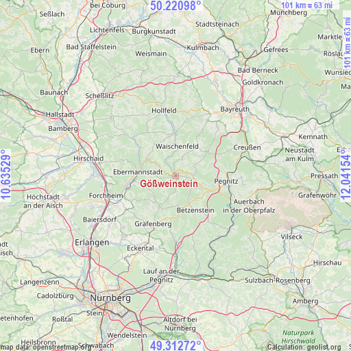
Gößweinstein GPS coordinates[2]
49° 46' 8.328" North, 11° 20' 18.276" East
| Map corner | latitude | longitude |
|---|---|---|
| Upper-left | 50.22098°, | 10.63529° |
| Center: | 49.76898°, | 11.33841° |
| Lower-right: | 49.31272°, | 12.04154° |
| Map W x H: | 101×101 km | = 62.8×62.8mi |
| max Lat: | 55.01917° ⇑69.7% North |
| Gößweinstein: | 49.76898° |
| min Lat: | ⇓30.3% South 47.40724° |
| min Long | Gößweinstein | max Long |
| 5.92978° | 11.33841° | 14.98853° |
| W 71.8%⇐ | ⇒28.2% E |
Elevation
Elevation of Gößweinstein is 465 m = 1526 ft, and this is 215.9 m = 708 ft above average elevation for this country.
| Max E: |
1256 m = 4121 ft | 15.5% |
| Gößweinstein | 465 m 1526 ft | |
| Avg. | 249.1 m = 817 ft | |
Min E: |
-5 m = -16 ft | 84.5% |
See also: Germany elevation on elevation.city.
Geographical zone
Gößweinstein is located in North temperate zone (between Tropic of Cancer and the Arctic Circle). Distance of this North polar circle is 1867.4 km =1160.3 mi to North.| Distance of | km | miles | from Gößweinstein |
|---|---|---|---|
| North Pole | 4473.3 | 2779.6 | to North |
| Arctic Circle | 1867.4 | 1160.3 | to North |
| Tropic Cancer | 2927.9 | 1819.3 | to South |
| Equator | 5533.8 | 3438.5 | to South |


Nearby cities:
15 places around Gößweinstein: (largest is in red/bold)
• Aufseß
15.1 km =9.4 mi,  327°
327°
• Ebermannstadt
11.3 km =7 mi,  277°
277°
• Egloffstein
9.5 km =5.9 mi,  217°
217°
• Glashütten
15.4 km =9.6 mi,  30°
30°
• Gräfenberg
15.3 km =9.5 mi,  204°
204°
• Hiltpoltstein
12.1 km =7.5 mi,  185°
185°
• Kirchehrenbach
14.1 km =8.8 mi,  253°
253°
• Leutenbach
13.6 km =8.5 mi,  241°
241°
• Obertrubach
7.7 km =4.8 mi,  173°
173°
• Pegnitz
14.7 km =9.1 mi,  97°
97°
• Plankenfels
12.7 km =7.9 mi,  358°
358°
• Pottenstein
5 km =3.1 mi,  87°
87°
• Pretzfeld
11.9 km =7.4 mi,  262°
262°
• Unterleinleiter
12.3 km =7.6 mi,  299°
299°
• Waischenfeld
8.6 km =5.3 mi,  4°
4°
Sources, notices
• [Note1] Compared only with cities in Germany existing in our database
• [Src1] Map data: © OpenStreetMap contributors (CC-BY-SA)
• [Src2] Other city data from geonames.org with taken over terms of usage.
• [Src3] Geographical zone / Annual Mean Temperature by Robert A. Rohde @ Wikipedia
