Löhma geodata
Löhma (Thuringia) is a seat of a fourth-order administrative division; located in Germany in Europe/Berlin (GMT+2) time zone. In our database, there are 11009 cities with bigger population. Compared to other cities in Germany, 50.2% of cities are located further ↑North; 79.6% of cities are located further ←West and 79% of cities have lower elevation than Löhma. Note1


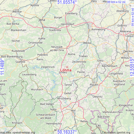
Löhma GPS coordinates[2]
50° 36' 42.012" North, 11° 51' 7.272" East
| Map corner | latitude | longitude |
|---|---|---|
| Upper-left | 51.05574°, | 11.1489° |
| Center: | 50.61167°, | 11.85202° |
| Lower-right: | 50.16337°, | 12.55515° |
| Map W x H: | 99.2×99.2 km | = 61.6×61.6mi |
| max Lat: | 55.01917° ⇑50.2% North |
| Löhma: | 50.61167° |
| min Lat: | ⇓49.8% South 47.40724° |
| min Long | Löhma | max Long |
| 5.92978° | 11.85202° | 14.98853° |
| W 79.6%⇐ | ⇒20.4% E |
Elevation
Elevation of Löhma is 427 m = 1401 ft, and this is 177.9 m = 584 ft above average elevation for this country.
| Max E: |
1256 m = 4121 ft | 21% |
| Löhma | 427 m 1401 ft | |
| Avg. | 249.1 m = 817 ft | |
Min E: |
-5 m = -16 ft | 79% |
See also: Germany elevation on elevation.city.
Geographical zone
Löhma is located in North temperate zone (between Tropic of Cancer and the Arctic Circle). Distance of this North polar circle is 1773.7 km =1102.1 mi to North.| Distance of | km | miles | from Löhma |
|---|---|---|---|
| North Pole | 4379.6 | 2721.4 | to North |
| Arctic Circle | 1773.7 | 1102.1 | to North |
| Tropic Cancer | 3021.6 | 1877.5 | to South |
| Equator | 5627.5 | 3496.8 | to South |


Nearby cities:
15 places around Löhma: (largest is in red/bold)
• Chursdorf
6.1 km =3.8 mi,  358°
358°
• Crispendorf
8.6 km =5.3 mi,  254°
254°
• Dittersdorf
4.9 km =3 mi,  329°
329°
• Görkwitz
5.8 km =3.6 mi,  236°
236°
• Göschitz
2.6 km =1.6 mi,  23°
23°
• Kirschkau
2.6 km =1.6 mi,  106°
106°
• Langenwolschendorf
7.7 km =4.8 mi,  69°
69°
• Moßbach
8.3 km =5.2 mi,  342°
342°
• Oettersdorf
2.8 km =1.7 mi, 242°
• Plothen
6.5 km =4 mi,  291°
291°
• Pörmitz
2.6 km =1.6 mi,  282°
282°
• Reinsdorf
7.6 km =4.7 mi, 358°
• Schleiz
4.7 km =2.9 mi,  218°
218°
• Tegau
4.4 km =2.7 mi,  13°
13°
• Volkmannsdorf
8.5 km =5.3 mi,  269°
269°
Sources, notices
• [Note1] Compared only with cities in Germany existing in our database
• [Src1] Map data: © OpenStreetMap contributors (CC-BY-SA)
• [Src2] Other city data from geonames.org with taken over terms of usage.
• [Src3] Geographical zone / Annual Mean Temperature by Robert A. Rohde @ Wikipedia
