Chursdorf geodata
Chursdorf (Thuringia) is a seat of a fourth-order administrative division; located in Germany in Europe/Berlin (GMT+2) time zone. With population of 236 people, there are 10325 cities with bigger population in this country. Compared to other cities in Germany, 51.1% of cities are located further ↓South; 79.5% of cities are located further ←West and 79.9% of cities have lower elevation than Chursdorf. Note1


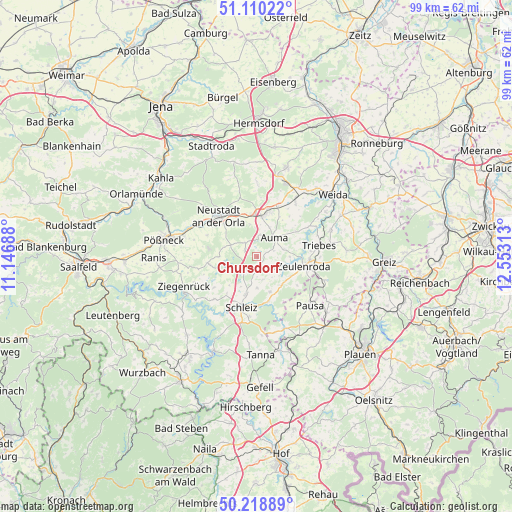
Chursdorf GPS coordinates[2]
50° 40' 0.012" North, 11° 51' 0" East
| Map corner | latitude | longitude |
|---|---|---|
| Upper-left | 51.11022°, | 11.14688° |
| Center: | 50.66667°, | 11.85° |
| Lower-right: | 50.21889°, | 12.55313° |
| Map W x H: | 99.1×99.1 km | = 61.6×61.6mi |
| max Lat: | 55.01917° ⇑48.9% North |
| Chursdorf: | 50.66667° |
| min Lat: | ⇓51.1% South 47.40724° |
| min Long | Chursdorf | max Long |
| 5.92978° | 11.85° | 14.98853° |
| W 79.5%⇐ | ⇒20.5% E |
Elevation
Elevation of Chursdorf is 432 m = 1417 ft, and this is 182.9 m = 600 ft above average elevation for this country.
| Max E: |
1256 m = 4121 ft | 20.1% |
| Chursdorf | 432 m 1417 ft | |
| Avg. | 249.1 m = 817 ft | |
Min E: |
-5 m = -16 ft | 79.9% |
See also: Germany elevation on elevation.city.
Geographical zone
Chursdorf is located in North temperate zone (between Tropic of Cancer and the Arctic Circle). Distance of this North polar circle is 1767.6 km =1098.3 mi to North.| Distance of | km | miles | from Chursdorf |
|---|---|---|---|
| North Pole | 4373.5 | 2717.6 | to North |
| Arctic Circle | 1767.6 | 1098.3 | to North |
| Tropic Cancer | 3027.7 | 1881.3 | to South |
| Equator | 5633.6 | 3500.6 | to South |


Nearby cities:
15 places around Chursdorf: (largest is in red/bold)
• Auma
5.1 km =3.2 mi,  42°
42°
• Dittersdorf
3 km =1.9 mi,  231°
231°
• Dreba
7 km =4.3 mi,  270°
270°
• Göschitz
3.9 km =2.4 mi,  162°
162°
• Kirschkau
7.4 km =4.6 mi, 159°
• Lemnitz
6.2 km =3.9 mi,  349°
349°
• Löhma
6.1 km =3.8 mi,  178°
178°
• Miesitz
7.5 km =4.7 mi, 350°
• Moßbach
3 km =1.9 mi,  308°
308°
• Plothen
6.9 km =4.3 mi,  237°
237°
• Pörmitz
6 km =3.7 mi,  202°
202°
• Reinsdorf
1.5 km =0.9 mi,  359°
359°
• Schmieritz
6.6 km =4.1 mi,  327°
327°
• Tegau
2.2 km =1.4 mi,  147°
147°
• Tömmelsdorf
5.7 km =3.5 mi,  11°
11°
Sources, notices
• [Note1] Compared only with cities in Germany existing in our database
• [Src1] Map data: © OpenStreetMap contributors (CC-BY-SA)
• [Src2] Other city data from geonames.org with taken over terms of usage.
• [Src3] Geographical zone / Annual Mean Temperature by Robert A. Rohde @ Wikipedia
