Plößberg geodata
Plößberg (Bavaria) is a populated place; located in Germany in Europe/Berlin (GMT+2) time zone. With population of 3,531 people, there are 3589 cities with bigger population in this country. Compared to other cities in Germany, 65.8% of cities are located further ↑North; 79.9% of cities are located further ←West and 92.5% of cities have lower elevation than Plößberg. Note1
Administrative division(s):
- Level 1: Bavaria
- Level 2: Upper Palatinate
- Level 3: Landkreis Tirschenreuth
- Level 4: Immenreuth


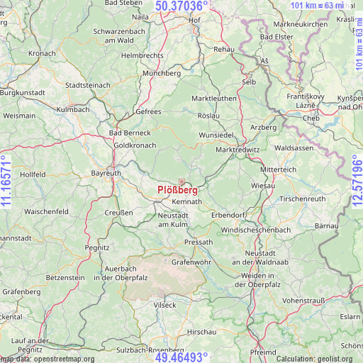
Plößberg GPS coordinates[2]
49° 55' 11.172" North, 11° 52' 7.788" East
| Map corner | latitude | longitude |
|---|---|---|
| Upper-left | 50.37036°, | 11.16571° |
| Center: | 49.91977°, | 11.86883° |
| Lower-right: | 49.46493°, | 12.57196° |
| Map W x H: | 100.7×100.7 km | = 62.6×62.6mi |
| max Lat: | 55.01917° ⇑65.8% North |
| Plößberg: | 49.91977° |
| min Lat: | ⇓34.2% South 47.40724° |
| min Long | Plößberg | max Long |
| 5.92978° | 11.86883° | 14.98853° |
| W 79.9%⇐ | ⇒20.1% E |
Elevation
Elevation of Plößberg is 550 m = 1804 ft, and this is 300.9 m = 987 ft above average elevation for this country.
| Max E: |
1256 m = 4121 ft | 7.5% |
| Plößberg | 550 m 1804 ft | |
| Avg. | 249.1 m = 817 ft | |
Min E: |
-5 m = -16 ft | 92.5% |
See also: Germany elevation on elevation.city.
Geographical zone
Plößberg is located in North temperate zone (between Tropic of Cancer and the Arctic Circle). Distance of this North polar circle is 1850.6 km =1149.9 mi to North.| Distance of | km | miles | from Plößberg |
|---|---|---|---|
| North Pole | 4456.5 | 2769.1 | to North |
| Arctic Circle | 1850.6 | 1149.9 | to North |
| Tropic Cancer | 2944.6 | 1829.7 | to South |
| Equator | 5550.6 | 3449 | to South |


Nearby cities:
15 places around Plößberg: (largest is in red/bold)
• Brand
5.4 km =3.4 mi,  34°
34°
• Ebnath
5.7 km =3.5 mi,  53°
53°
• Fichtelberg
9.3 km =5.8 mi,  353°
353°
• Immenreuth
2.2 km =1.4 mi,  184°
184°
• Kastl
9.9 km =6.2 mi,  166°
166°
• Kemnath
5.7 km =3.5 mi,  164°
164°
• Kirchenpingarten
6.3 km =3.9 mi,  283°
283°
• Kulmain
3.1 km =1.9 mi,  134°
134°
• Mehlmeisel
6.1 km =3.8 mi,  355°
355°
• Nagel
7.9 km =4.9 mi, 25°
• Neusorg
7.2 km =4.5 mi,  77°
77°
• Pullenreuth
9.5 km =5.9 mi, 80°
• Seybothenreuth
12.1 km =7.5 mi,  256°
256°
• Speichersdorf
8.3 km =5.2 mi,  229°
229°
• Warmensteinach
10.4 km =6.5 mi,  321°
321°
Sources, notices
• [Note1] Compared only with cities in Germany existing in our database
• [Src1] Map data: © OpenStreetMap contributors (CC-BY-SA)
• [Src2] Other city data from geonames.org with taken over terms of usage.
• [Src3] Geographical zone / Annual Mean Temperature by Robert A. Rohde @ Wikipedia
