Kulmain geodata
Kulmain (Bavaria) is a seat of a fourth-order administrative division; located in Germany in Europe/Berlin (GMT+2) time zone. With population of 2,452 people, there are 4500 cities with bigger population in this country. Compared to other cities in Germany, 66.6% of cities are located further ↑North; 80.3% of cities are located further ←West and 88.6% of cities have lower elevation than Kulmain. Note1
Administrative division(s):
- Level 1: Bavaria
- Level 2: Upper Palatinate
- Level 3: Landkreis Tirschenreuth
- Level 4: Kulmain


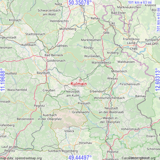
Kulmain GPS coordinates[2]
49° 54' 0" North, 11° 54' 0" East
| Map corner | latitude | longitude |
|---|---|---|
| Upper-left | 50.35078°, | 11.19688° |
| Center: | 49.9°, | 11.9° |
| Lower-right: | 49.44497°, | 12.60313° |
| Map W x H: | 100.7×100.7 km | = 62.6×62.6mi |
| max Lat: | 55.01917° ⇑66.6% North |
| Kulmain: | 49.9° |
| min Lat: | ⇓33.4% South 47.40724° |
| min Long | Kulmain | max Long |
| 5.92978° | 11.9° | 14.98853° |
| W 80.3%⇐ | ⇒19.7% E |
Elevation
Elevation of Kulmain is 500 m = 1640 ft, and this is 250.9 m = 823 ft above average elevation for this country.
| Max E: |
1256 m = 4121 ft | 11.4% |
| Kulmain | 500 m 1640 ft | |
| Avg. | 249.1 m = 817 ft | |
Min E: |
-5 m = -16 ft | 88.6% |
See also: Germany elevation on elevation.city.
Geographical zone
Kulmain is located in North temperate zone (between Tropic of Cancer and the Arctic Circle). Distance of this North polar circle is 1852.8 km =1151.3 mi to North.| Distance of | km | miles | from Kulmain |
|---|---|---|---|
| North Pole | 4458.7 | 2770.5 | to North |
| Arctic Circle | 1852.8 | 1151.3 | to North |
| Tropic Cancer | 2942.4 | 1828.3 | to South |
| Equator | 5548.4 | 3447.6 | to South |


Nearby cities:
15 places around Kulmain: (largest is in red/bold)
• Brand
6.7 km =4.2 mi,  6°
6°
• Ebnath
6 km =3.7 mi,  23°
23°
• Erbendorf
12.4 km =7.7 mi,  122°
122°
• Fichtelberg
11.9 km =7.4 mi,  344°
344°
• Immenreuth
2.4 km =1.5 mi,  270°
270°
• Kastl
7.4 km =4.6 mi,  180°
180°
• Kemnath
3.4 km =2.1 mi,  191°
191°
• Kirchenpingarten
9.1 km =5.7 mi,  293°
293°
• Mehlmeisel
8.7 km =5.4 mi, 341°
• Nagel
9.3 km =5.8 mi, 7°
• Neusorg
6 km =3.7 mi,  52°
52°
• Plößberg
3.1 km =1.9 mi,  314°
314°
• Pullenreuth
8.1 km =5 mi,  62°
62°
• Speichersdorf
9.1 km =5.7 mi,  249°
249°
• Trabitz
11.1 km =6.9 mi, 180°
Sources, notices
• [Note1] Compared only with cities in Germany existing in our database
• [Src1] Map data: © OpenStreetMap contributors (CC-BY-SA)
• [Src2] Other city data from geonames.org with taken over terms of usage.
• [Src3] Geographical zone / Annual Mean Temperature by Robert A. Rohde @ Wikipedia
