Pfaffenhausen geodata
Pfaffenhausen (Bavaria) is a populated place; located in Germany in Europe/Berlin (GMT+2) time zone. With population of 2,429 people, there are 4527 cities with bigger population in this country. Compared to other cities in Germany, 93.8% of cities are located further ↑North; 58.2% of cities are located further ←West and 93.4% of cities have lower elevation than Pfaffenhausen. Note1
Administrative division(s):
- Level 1: Bavaria
- Level 2: Swabia
- Level 3: Landkreis Unterallgäu
- Level 4: Pfaffenhausen, Markt


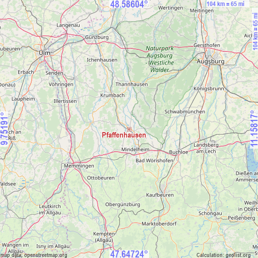
Pfaffenhausen GPS coordinates[2]
48° 7' 7.608" North, 10° 27' 18.144" East
| Map corner | latitude | longitude |
|---|---|---|
| Upper-left | 48.58604°, | 9.75191° |
| Center: | 48.11878°, | 10.45504° |
| Lower-right: | 47.64724°, | 11.15817° |
| Map W x H: | 104.4×104.4 km | = 64.9×64.9mi |
| max Lat: | 55.01917° ⇑93.8% North |
| Pfaffenhausen: | 48.11878° |
| min Lat: | ⇓6.2% South 47.40724° |
| min Long | Pfaffenhausen | max Long |
| 5.92978° | 10.45504° | 14.98853° |
| W 58.2%⇐ | ⇒41.8% E |
Elevation
Elevation of Pfaffenhausen is 564 m = 1850 ft, and this is 314.9 m = 1033 ft above average elevation for this country.
| Max E: |
1256 m = 4121 ft | 6.6% |
| Pfaffenhausen | 564 m 1850 ft | |
| Avg. | 249.1 m = 817 ft | |
Min E: |
-5 m = -16 ft | 93.4% |
See also: Germany elevation on elevation.city.
Geographical zone
Pfaffenhausen is located in North temperate zone (between Tropic of Cancer and the Arctic Circle). Distance of this North polar circle is 2050.9 km =1274.4 mi to North.| Distance of | km | miles | from Pfaffenhausen |
|---|---|---|---|
| North Pole | 4656.8 | 2893.6 | to North |
| Arctic Circle | 2050.9 | 1274.4 | to North |
| Tropic Cancer | 2744.4 | 1705.3 | to South |
| Equator | 5350.3 | 3324.5 | to South |


Nearby cities:
15 places around Pfaffenhausen: (largest is in red/bold)
• Aletshausen
10.1 km =6.3 mi,  331°
331°
• Apfeltrach
11.8 km =7.3 mi,  163°
163°
• Breitenbrunn
4.4 km =2.7 mi,  291°
291°
• Eppishausen
7 km =4.3 mi,  40°
40°
• Kirchhaslach
11.3 km =7 mi, 288°
• Kirchheim
6.4 km =4 mi,  13°
13°
• Markt Wald
9.6 km =6 mi,  77°
77°
• Mindelheim
8.6 km =5.3 mi, 161°
• Mittelneufnach
12.4 km =7.7 mi,  58°
58°
• Oberrieden
4 km =2.5 mi,  212°
212°
• Oberschönegg
11.7 km =7.3 mi,  264°
264°
• Salgen
2.2 km =1.4 mi,  53°
53°
• Stetten
10.6 km =6.6 mi,  184°
184°
• Tussenhausen
8.1 km =5 mi,  103°
103°
• Waltenhausen
10.4 km =6.5 mi,  319°
319°
Sources, notices
• [Note1] Compared only with cities in Germany existing in our database
• [Src1] Map data: © OpenStreetMap contributors (CC-BY-SA)
• [Src2] Other city data from geonames.org with taken over terms of usage.
• [Src3] Geographical zone / Annual Mean Temperature by Robert A. Rohde @ Wikipedia
