Breitenbrunn geodata
Breitenbrunn (Bavaria) is a seat of a fourth-order administrative division; located in Germany in Europe/Berlin (GMT+2) time zone. With population of 2,300 people, there are 4670 cities with bigger population in this country. Compared to other cities in Germany, 93.6% of cities are located further ↑North; 57.1% of cities are located further ←West and 92.9% of cities have lower elevation than Breitenbrunn. Note1
Administrative division(s):
- Level 1: Bavaria
- Level 2: Swabia
- Level 3: Landkreis Unterallgäu
- Level 4: Breitenbrunn


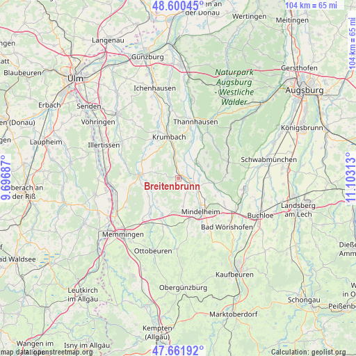
Breitenbrunn GPS coordinates[2]
48° 7' 59.988" North, 10° 24' 0" East
| Map corner | latitude | longitude |
|---|---|---|
| Upper-left | 48.60045°, | 9.69687° |
| Center: | 48.13333°, | 10.4° |
| Lower-right: | 47.66192°, | 11.10313° |
| Map W x H: | 104.4×104.4 km | = 64.9×64.9mi |
| max Lat: | 55.01917° ⇑93.6% North |
| Breitenbrunn: | 48.13333° |
| min Lat: | ⇓6.4% South 47.40724° |
| min Long | Breitenbrunn | max Long |
| 5.92978° | 10.4° | 14.98853° |
| W 57.1%⇐ | ⇒42.9% E |
Elevation
Elevation of Breitenbrunn is 556 m = 1824 ft, and this is 306.9 m = 1007 ft above average elevation for this country.
| Max E: |
1256 m = 4121 ft | 7.1% |
| Breitenbrunn | 556 m 1824 ft | |
| Avg. | 249.1 m = 817 ft | |
Min E: |
-5 m = -16 ft | 92.9% |
See also: Germany elevation on elevation.city.
Geographical zone
Breitenbrunn is located in North temperate zone (between Tropic of Cancer and the Arctic Circle). Distance of this North polar circle is 2049.2 km =1273.3 mi to North.| Distance of | km | miles | from Breitenbrunn |
|---|---|---|---|
| North Pole | 4655.1 | 2892.5 | to North |
| Arctic Circle | 2049.2 | 1273.3 | to North |
| Tropic Cancer | 2746 | 1706.3 | to South |
| Equator | 5351.9 | 3325.5 | to South |


Nearby cities:
15 places around Breitenbrunn: (largest is in red/bold)
• Aletshausen
7.3 km =4.5 mi,  353°
353°
• Babenhausen
11 km =6.8 mi,  276°
276°
• Ebershausen
10.2 km =6.3 mi,  322°
322°
• Egg an der Günz
10 km =6.2 mi,  238°
238°
• Eppishausen
9.4 km =5.8 mi,  66°
66°
• Erkheim
11.7 km =7.3 mi,  204°
204°
• Kettershausen
11.3 km =7 mi,  299°
299°
• Kirchhaslach
6.9 km =4.3 mi,  285°
285°
• Kirchheim
7.2 km =4.5 mi,  50°
50°
• Lauben
11.6 km =7.2 mi,  224°
224°
• Oberrieden
5.3 km =3.3 mi,  158°
158°
• Oberschönegg
8 km =5 mi,  249°
249°
• Pfaffenhausen
4.4 km =2.7 mi,  111°
111°
• Salgen
5.9 km =3.7 mi,  92°
92°
• Waltenhausen
6.9 km =4.3 mi,  337°
337°
Sources, notices
• [Note1] Compared only with cities in Germany existing in our database
• [Src1] Map data: © OpenStreetMap contributors (CC-BY-SA)
• [Src2] Other city data from geonames.org with taken over terms of usage.
• [Src3] Geographical zone / Annual Mean Temperature by Robert A. Rohde @ Wikipedia
