Oberrieden geodata
Oberrieden (Bavaria) is a seat of a fourth-order administrative division; located in Germany in Europe/Berlin (GMT+2) time zone. With population of 1,247 people, there are 6457 cities with bigger population in this country. Compared to other cities in Germany, 94.2% of cities are located further ↑North; 57.6% of cities are located further ←West and 94.1% of cities have lower elevation than Oberrieden. Note1
Administrative division(s):
- Level 1: Bavaria
- Level 2: Swabia
- Level 3: Landkreis Unterallgäu
- Level 4: Oberrieden


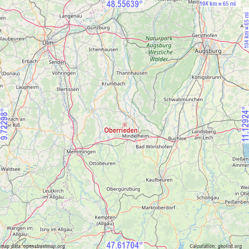
Oberrieden GPS coordinates[2]
48° 5' 19.896" North, 10° 25' 33.996" East
| Map corner | latitude | longitude |
|---|---|---|
| Upper-left | 48.55639°, | 9.72298° |
| Center: | 48.08886°, | 10.42611° |
| Lower-right: | 47.61704°, | 11.12924° |
| Map W x H: | 104.4×104.4 km | = 64.9×64.9mi |
| max Lat: | 55.01917° ⇑94.2% North |
| Oberrieden: | 48.08886° |
| min Lat: | ⇓5.8% South 47.40724° |
| min Long | Oberrieden | max Long |
| 5.92978° | 10.42611° | 14.98853° |
| W 57.6%⇐ | ⇒42.4% E |
Elevation
Elevation of Oberrieden is 576 m = 1890 ft, and this is 326.9 m = 1073 ft above average elevation for this country.
| Max E: |
1256 m = 4121 ft | 5.9% |
| Oberrieden | 576 m 1890 ft | |
| Avg. | 249.1 m = 817 ft | |
Min E: |
-5 m = -16 ft | 94.1% |
See also: Germany elevation on elevation.city.
Geographical zone
Oberrieden is located in North temperate zone (between Tropic of Cancer and the Arctic Circle). Distance of this North polar circle is 2054.2 km =1276.4 mi to North.| Distance of | km | miles | from Oberrieden |
|---|---|---|---|
| North Pole | 4660.1 | 2895.7 | to North |
| Arctic Circle | 2054.2 | 1276.4 | to North |
| Tropic Cancer | 2741.1 | 1703.2 | to South |
| Equator | 5347 | 3322.5 | to South |


Nearby cities:
15 places around Oberrieden: (largest is in red/bold)
• Apfeltrach
9.7 km =6 mi,  145°
145°
• Breitenbrunn
5.3 km =3.3 mi,  338°
338°
• Egg an der Günz
10.5 km =6.5 mi,  268°
268°
• Eppishausen
11 km =6.8 mi,  37°
37°
• Erkheim
8.8 km =5.5 mi,  229°
229°
• Kirchhaslach
11 km =6.8 mi,  308°
308°
• Kirchheim
10.2 km =6.3 mi,  20°
20°
• Lauben
10.6 km =6.6 mi,  251°
251°
• Mindelheim
6.9 km =4.3 mi,  134°
134°
• Oberschönegg
9.7 km =6 mi,  282°
282°
• Pfaffenhausen
4 km =2.5 mi,  32°
32°
• Salgen
6.1 km =3.8 mi, 40°
• Sontheim
10.5 km =6.5 mi,  210°
210°
• Stetten
7.4 km =4.6 mi,  169°
169°
• Tussenhausen
10.1 km =6.3 mi,  81°
81°
Sources, notices
• [Note1] Compared only with cities in Germany existing in our database
• [Src1] Map data: © OpenStreetMap contributors (CC-BY-SA)
• [Src2] Other city data from geonames.org with taken over terms of usage.
• [Src3] Geographical zone / Annual Mean Temperature by Robert A. Rohde @ Wikipedia
