Stetten geodata
Stetten (Bavaria) is a seat of a fourth-order administrative division; located in Germany in Europe/Berlin (GMT+2) time zone. With population of 1,365 people, there are 6151 cities with bigger population in this country. Compared to other cities in Germany, 95.2% of cities are located further ↑North; 58% of cities are located further ←West and 95.8% of cities have lower elevation than Stetten. Note1
Administrative division(s):
- Level 1: Bavaria
- Level 2: Swabia
- Level 3: Landkreis Unterallgäu
- Level 4: Stetten


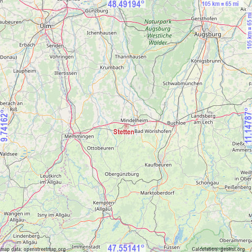
Stetten GPS coordinates[2]
48° 1' 25.752" North, 10° 26' 41.064" East
| Map corner | latitude | longitude |
|---|---|---|
| Upper-left | 48.49194°, | 9.74162° |
| Center: | 48.02382°, | 10.44474° |
| Lower-right: | 47.55141°, | 11.14787° |
| Map W x H: | 104.6×104.6 km | = 65×65mi |
| max Lat: | 55.01917° ⇑95.2% North |
| Stetten: | 48.02382° |
| min Lat: | ⇓4.8% South 47.40724° |
| min Long | Stetten | max Long |
| 5.92978° | 10.44474° | 14.98853° |
| W 58%⇐ | ⇒42% E |
Elevation
Elevation of Stetten is 619 m = 2031 ft, and this is 369.9 m = 1214 ft above average elevation for this country.
| Max E: |
1256 m = 4121 ft | 4.2% |
| Stetten | 619 m 2031 ft | |
| Avg. | 249.1 m = 817 ft | |
Min E: |
-5 m = -16 ft | 95.8% |
See also: Germany elevation on elevation.city.
Geographical zone
Stetten is located in North temperate zone (between Tropic of Cancer and the Arctic Circle). Distance of this North polar circle is 2061.4 km =1280.9 mi to North.| Distance of | km | miles | from Stetten |
|---|---|---|---|
| North Pole | 4667.3 | 2900.1 | to North |
| Arctic Circle | 2061.4 | 1280.9 | to North |
| Tropic Cancer | 2733.8 | 1698.7 | to South |
| Equator | 5339.7 | 3317.9 | to South |


Nearby cities:
15 places around Stetten: (largest is in red/bold)
• Apfeltrach
4.2 km =2.6 mi,  100°
100°
• Bad Wörishofen
11.5 km =7.1 mi, 99°
• Baisweil
11.3 km =7 mi,  141°
141°
• Dirlewang
5 km =3.1 mi,  119°
119°
• Erkheim
8.2 km =5.1 mi,  280°
280°
• Lauben
12.2 km =7.6 mi,  288°
288°
• Markt Rettenbach
9.2 km =5.7 mi,  203°
203°
• Mindelheim
4.3 km =2.7 mi,  55°
55°
• Oberrieden
7.4 km =4.6 mi,  349°
349°
• Pfaffenhausen
10.6 km =6.6 mi,  4°
4°
• Salgen
12.2 km =7.6 mi,  12°
12°
• Sontheim
7 km =4.3 mi,  254°
254°
• Unteregg
6.6 km =4.1 mi,  165°
165°
• Wald
12.2 km =7.6 mi,  241°
241°
• Westerheim
10.8 km =6.7 mi,  265°
265°
Sources, notices
• [Note1] Compared only with cities in Germany existing in our database
• [Src1] Map data: © OpenStreetMap contributors (CC-BY-SA)
• [Src2] Other city data from geonames.org with taken over terms of usage.
• [Src3] Geographical zone / Annual Mean Temperature by Robert A. Rohde @ Wikipedia
