Perkam geodata
Perkam (Bavaria) is a seat of a fourth-order administrative division; located in Germany in Europe/Berlin (GMT+2) time zone. With population of 1,411 people, there are 6057 cities with bigger population in this country. Compared to other cities in Germany, 84.6% of cities are located further ↑North; 87.4% of cities are located further ←West and 69.7% of cities have lower elevation than Perkam. Note1
Administrative division(s):
- Level 1: Bavaria
- Level 2: Lower Bavaria
- Level 3: Landkreis Straubing-Bogen
- Level 4: Perkam


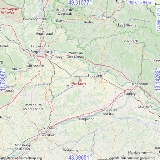
Perkam GPS coordinates[2]
48° 51' 19.008" North, 12° 26' 23.244" East
| Map corner | latitude | longitude |
|---|---|---|
| Upper-left | 49.31577°, | 11.73667° |
| Center: | 48.85528°, | 12.43979° |
| Lower-right: | 48.39051°, | 13.14292° |
| Map W x H: | 102.9×102.9 km | = 63.9×63.9mi |
| max Lat: | 55.01917° ⇑84.6% North |
| Perkam: | 48.85528° |
| min Lat: | ⇓15.4% South 47.40724° |
| min Long | Perkam | max Long |
| 5.92978° | 12.43979° | 14.98853° |
| W 87.4%⇐ | ⇒12.6% E |
Elevation
Elevation of Perkam is 356 m = 1168 ft, and this is 106.9 m = 351 ft above average elevation for this country.
| Max E: |
1256 m = 4121 ft | 30.3% |
| Perkam | 356 m 1168 ft | |
| Avg. | 249.1 m = 817 ft | |
Min E: |
-5 m = -16 ft | 69.7% |
See also: Germany elevation on elevation.city.
Geographical zone
Perkam is located in North temperate zone (between Tropic of Cancer and the Arctic Circle). Distance of this North polar circle is 1969 km =1223.5 mi to North.| Distance of | km | miles | from Perkam |
|---|---|---|---|
| North Pole | 4574.9 | 2842.7 | to North |
| Arctic Circle | 1969 | 1223.5 | to North |
| Tropic Cancer | 2826.3 | 1756.2 | to South |
| Equator | 5432.2 | 3375.4 | to South |


Nearby cities:
15 places around Perkam: (largest is in red/bold)
• Aholfing
10 km =6.2 mi,  12°
12°
• Alterhofen
13.2 km =8.2 mi,  94°
94°
• Atting
5.6 km =3.5 mi,  39°
39°
• Aufhausen
11.7 km =7.3 mi,  279°
279°
• Feldkirchen
6.7 km =4.2 mi,  106°
106°
• Geiselhöring
4.6 km =2.9 mi,  223°
223°
• Laberweinting
10.9 km =6.8 mi,  235°
235°
• Leiblfing
10.5 km =6.5 mi,  147°
147°
• Mötzing
6.4 km =4 mi,  311°
311°
• Pfatter
12.7 km =7.9 mi,  340°
340°
• Rain
5.9 km =3.7 mi,  20°
20°
• Riekofen
9.5 km =5.9 mi,  316°
316°
• Salching
10.8 km =6.7 mi,  117°
117°
• Straubing
10.2 km =6.3 mi,  73°
73°
• Sünching
7 km =4.3 mi,  291°
291°
Sources, notices
• [Note1] Compared only with cities in Germany existing in our database
• [Src1] Map data: © OpenStreetMap contributors (CC-BY-SA)
• [Src2] Other city data from geonames.org with taken over terms of usage.
• [Src3] Geographical zone / Annual Mean Temperature by Robert A. Rohde @ Wikipedia
