Geiselhöring geodata
Geiselhöring (Bavaria) is a populated place; located in Germany in Europe/Berlin (GMT+2) time zone. With population of 6,872 people, there are 2210 cities with bigger population in this country. Compared to other cities in Germany, 85% of cities are located further ↑North; 86.9% of cities are located further ←West and 69.7% of cities have lower elevation than Geiselhöring. Note1
Administrative division(s):
- Level 1: Bavaria
- Level 2: Lower Bavaria
- Level 3: Landkreis Straubing-Bogen
- Level 4: Geiselhöring


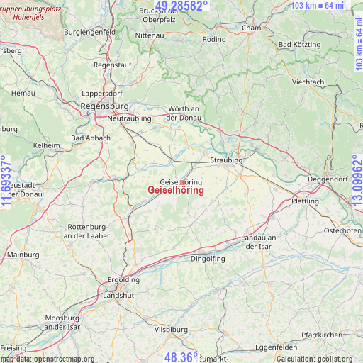
Geiselhöring GPS coordinates[2]
48° 49' 30.18" North, 12° 23' 47.364" East
| Map corner | latitude | longitude |
|---|---|---|
| Upper-left | 49.28582°, | 11.69337° |
| Center: | 48.82505°, | 12.39649° |
| Lower-right: | 48.36°, | 13.09962° |
| Map W x H: | 102.9×102.9 km | = 63.9×63.9mi |
| max Lat: | 55.01917° ⇑85% North |
| Geiselhöring: | 48.82505° |
| min Lat: | ⇓15% South 47.40724° |
| min Long | Geiselhöring | max Long |
| 5.92978° | 12.39649° | 14.98853° |
| W 86.9%⇐ | ⇒13.1% E |
Elevation
Elevation of Geiselhöring is 356 m = 1168 ft, and this is 106.9 m = 351 ft above average elevation for this country.
| Max E: |
1256 m = 4121 ft | 30.3% |
| Geiselhöring | 356 m 1168 ft | |
| Avg. | 249.1 m = 817 ft | |
Min E: |
-5 m = -16 ft | 69.7% |
See also: Germany elevation on elevation.city.
Geographical zone
Geiselhöring is located in North temperate zone (between Tropic of Cancer and the Arctic Circle). Distance of this North polar circle is 1972.3 km =1225.5 mi to North.| Distance of | km | miles | from Geiselhöring |
|---|---|---|---|
| North Pole | 4578.2 | 2844.8 | to North |
| Arctic Circle | 1972.3 | 1225.5 | to North |
| Tropic Cancer | 2822.9 | 1754.1 | to South |
| Equator | 5428.8 | 3373.3 | to South |


Nearby cities:
15 places around Geiselhöring: (largest is in red/bold)
• Aholfing
14.1 km =8.8 mi,  21°
21°
• Atting
10.2 km =6.3 mi,  41°
41°
• Aufhausen
9.9 km =6.2 mi,  301°
301°
• Feldkirchen
9.7 km =6 mi,  81°
81°
• Laberweinting
6.5 km =4 mi,  244°
244°
• Leiblfing
10.5 km =6.5 mi,  121°
121°
• Mallersdorf-Pfaffenberg
13.8 km =8.6 mi, 241°
• Mengkofen
12.2 km =7.6 mi,  164°
164°
• Mötzing
7.8 km =4.8 mi,  347°
347°
• Perkam
4.6 km =2.9 mi, 43°
• Pfakofen
12.9 km =8 mi,  286°
286°
• Rain
10.3 km =6.4 mi,  30°
30°
• Riekofen
10.7 km =6.6 mi,  341°
341°
• Salching
12.8 km =8 mi,  97°
97°
• Sünching
6.8 km =4.2 mi,  330°
330°
Sources, notices
• [Note1] Compared only with cities in Germany existing in our database
• [Src1] Map data: © OpenStreetMap contributors (CC-BY-SA)
• [Src2] Other city data from geonames.org with taken over terms of usage.
• [Src3] Geographical zone / Annual Mean Temperature by Robert A. Rohde @ Wikipedia
