Pegau geodata
Pegau (Saxony) is a populated place; located in Germany in Europe/Berlin (GMT+2) time zone. With population of 4,759 people, there are 2917 cities with bigger population in this country. Compared to other cities in Germany, 61.1% of cities are located further ↓South; 85.3% of cities are located further ←West and 62.3% of cities have higher elevation than Pegau. Note1


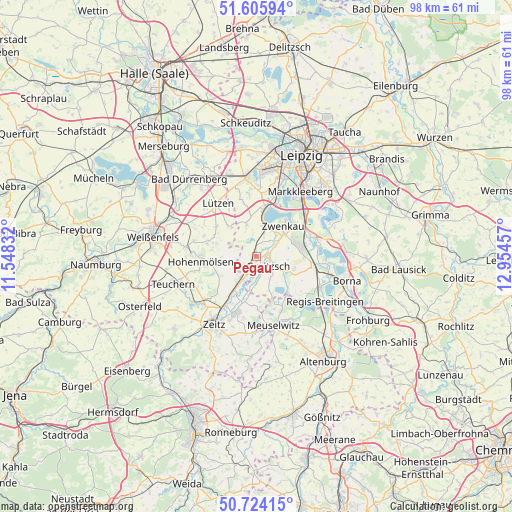
Pegau GPS coordinates[2]
51° 10' 1.74" North, 12° 15' 5.184" East
| Map corner | latitude | longitude |
|---|---|---|
| Upper-left | 51.60594°, | 11.54832° |
| Center: | 51.16715°, | 12.25144° |
| Lower-right: | 50.72415°, | 12.95457° |
| Map W x H: | 98×98 km | = 60.9×60.9mi |
| max Lat: | 55.01917° ⇑38.9% North |
| Pegau: | 51.16715° |
| min Lat: | ⇓61.1% South 47.40724° |
| min Long | Pegau | max Long |
| 5.92978° | 12.25144° | 14.98853° |
| W 85.3%⇐ | ⇒14.7% E |
Elevation
Elevation of Pegau is 136 m = 446 ft, and this is 113.1 m = 371 ft below average elevation for this country.
| Max E: |
1256 m = 4121 ft | 62.3% |
| Avg. | 249.1 m = 817 ft | |
| Pegau | 136 m = 446 ft | |
Min E: |
-5 m = -16 ft | 37.7% |
See also: Germany elevation on elevation.city.
Geographical zone
Pegau is located in North temperate zone (between Tropic of Cancer and the Arctic Circle). Distance of this North polar circle is 1711.9 km =1063.7 mi to North.| Distance of | km | miles | from Pegau |
|---|---|---|---|
| North Pole | 4317.8 | 2683 | to North |
| Arctic Circle | 1711.9 | 1063.7 | to North |
| Tropic Cancer | 3083.3 | 1915.9 | to South |
| Equator | 5689.3 | 3535.2 | to South |


Nearby cities:
15 places around Pegau: (largest is in red/bold)
• Böhlen
10.1 km =6.3 mi,  68°
68°
• Elstertrebnitz
2.3 km =1.4 mi,  213°
213°
• Groitzsch
2.5 km =1.6 mi,  120°
120°
• Großgörschen
7.3 km =4.5 mi,  319°
319°
• Hohenmölsen
10.6 km =6.6 mi,  264°
264°
• Kitzen
6.4 km =4 mi,  342°
342°
• Lucka
9.6 km =6 mi,  143°
143°
• Muschwitz
9.6 km =6 mi,  287°
287°
• Neukieritzsch
11.3 km =7 mi,  99°
99°
• Nonnewitz
12.3 km =7.6 mi,  226°
226°
• Röcken
12.5 km =7.8 mi,  310°
310°
• Rötha
11.9 km =7.4 mi, 73°
• Starsiedel
9.6 km =6 mi, 305°
• Taucha
12.3 km =7.6 mi,  283°
283°
• Zwenkau
7.9 km =4.9 mi,  43°
43°
Sources, notices
• [Note1] Compared only with cities in Germany existing in our database
• [Src1] Map data: © OpenStreetMap contributors (CC-BY-SA)
• [Src2] Other city data from geonames.org with taken over terms of usage.
• [Src3] Geographical zone / Annual Mean Temperature by Robert A. Rohde @ Wikipedia
