Rötha geodata
Rötha (Saxony) is a populated place; located in Germany in Europe/Berlin (GMT+2) time zone. With population of 4,199 people, there are 3176 cities with bigger population in this country. Compared to other cities in Germany, 61.5% of cities are located further ↓South; 87.1% of cities are located further ←West and 61.9% of cities have higher elevation than Rötha. Note1


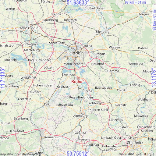
Rötha GPS coordinates[2]
51° 11' 52.188" North, 12° 24' 52.092" East
| Map corner | latitude | longitude |
|---|---|---|
| Upper-left | 51.63633°, | 11.71135° |
| Center: | 51.19783°, | 12.41447° |
| Lower-right: | 50.75512°, | 13.1176° |
| Map W x H: | 98×98 km | = 60.9×60.9mi |
| max Lat: | 55.01917° ⇑38.5% North |
| Rötha: | 51.19783° |
| min Lat: | ⇓61.5% South 47.40724° |
| min Long | Rötha | max Long |
| 5.92978° | 12.41447° | 14.98853° |
| W 87.1%⇐ | ⇒12.9% E |
Elevation
Elevation of Rötha is 139 m = 456 ft, and this is 110.1 m = 361 ft below average elevation for this country.
| Max E: |
1256 m = 4121 ft | 61.9% |
| Avg. | 249.1 m = 817 ft | |
| Rötha | 139 m = 456 ft | |
Min E: |
-5 m = -16 ft | 38.1% |
See also: Germany elevation on elevation.city.
Geographical zone
Rötha is located in North temperate zone (between Tropic of Cancer and the Arctic Circle). Distance of this North polar circle is 1708.5 km =1061.6 mi to North.| Distance of | km | miles | from Rötha |
|---|---|---|---|
| North Pole | 4314.4 | 2680.8 | to North |
| Arctic Circle | 1708.5 | 1061.6 | to North |
| Tropic Cancer | 3086.7 | 1918 | to South |
| Equator | 5692.7 | 3537.3 | to South |


Nearby cities:
15 places around Rötha: (largest is in red/bold)
• Belgershain
10.2 km =6.3 mi,  67°
67°
• Borna
10 km =6.2 mi,  145°
145°
• Böhlen
2 km =1.2 mi,  278°
278°
• Deutzen
9.6 km =6 mi,  175°
175°
• Espenhain
4.6 km =2.9 mi,  101°
101°
• Groitzsch
10.3 km =6.4 mi,  242°
242°
• Großpösna
9.7 km =6 mi,  37°
37°
• Kitzscher
10.3 km =6.4 mi,  111°
111°
• Lobstädt
7.5 km =4.7 mi,  161°
161°
• Lucka
12.5 km =7.8 mi,  206°
206°
• Markkleeberg
9.2 km =5.7 mi,  339°
339°
• Neukieritzsch
5.3 km =3.3 mi, 182°
• Pegau
11.9 km =7.4 mi,  253°
253°
• Regis-Breitingen
12.2 km =7.6 mi,  172°
172°
• Zwenkau
6.3 km =3.9 mi,  291°
291°
Sources, notices
• [Note1] Compared only with cities in Germany existing in our database
• [Src1] Map data: © OpenStreetMap contributors (CC-BY-SA)
• [Src2] Other city data from geonames.org with taken over terms of usage.
• [Src3] Geographical zone / Annual Mean Temperature by Robert A. Rohde @ Wikipedia
