Kirchweidach geodata
Kirchweidach (Bavaria) is a seat of a fourth-order administrative division; located in Germany in Europe/Berlin (GMT+2) time zone. With population of 2,274 people, there are 4712 cities with bigger population in this country. Compared to other cities in Germany, 94.3% of cities are located further ↑North; 89.3% of cities are located further ←West and 89.5% of cities have lower elevation than Kirchweidach. Note1
Administrative division(s):
- Level 1: Bavaria
- Level 2: Upper Bavaria
- Level 3: Landkreis Altötting
- Level 4: Kirchweidach


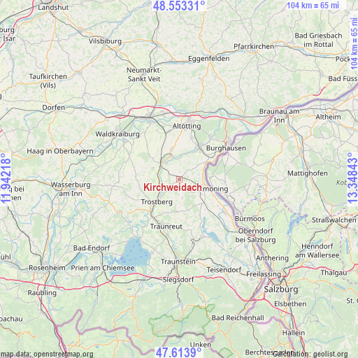
Kirchweidach GPS coordinates[2]
48° 5' 8.7" North, 12° 38' 43.08" East
| Map corner | latitude | longitude |
|---|---|---|
| Upper-left | 48.55331°, | 11.94218° |
| Center: | 48.08575°, | 12.6453° |
| Lower-right: | 47.6139°, | 13.34843° |
| Map W x H: | 104.5×104.5 km | = 64.9×64.9mi |
| max Lat: | 55.01917° ⇑94.3% North |
| Kirchweidach: | 48.08575° |
| min Lat: | ⇓5.7% South 47.40724° |
| min Long | Kirchweidach | max Long |
| 5.92978° | 12.6453° | 14.98853° |
| W 89.3%⇐ | ⇒10.7% E |
Elevation
Elevation of Kirchweidach is 508 m = 1667 ft, and this is 258.9 m = 849 ft above average elevation for this country.
| Max E: |
1256 m = 4121 ft | 10.5% |
| Kirchweidach | 508 m 1667 ft | |
| Avg. | 249.1 m = 817 ft | |
Min E: |
-5 m = -16 ft | 89.5% |
See also: Germany elevation on elevation.city.
Geographical zone
Kirchweidach is located in North temperate zone (between Tropic of Cancer and the Arctic Circle). Distance of this North polar circle is 2054.5 km =1276.6 mi to North.| Distance of | km | miles | from Kirchweidach |
|---|---|---|---|
| North Pole | 4660.4 | 2895.8 | to North |
| Arctic Circle | 2054.5 | 1276.6 | to North |
| Tropic Cancer | 2740.7 | 1703 | to South |
| Equator | 5346.6 | 3322.2 | to South |


Nearby cities:
15 places around Kirchweidach: (largest is in red/bold)
• Burgkirchen an der Alz
11.2 km =7 mi,  35°
35°
• Engelsberg
8.3 km =5.2 mi,  294°
294°
• Garching an der Alz
7.2 km =4.5 mi,  318°
318°
• Halsbach
6 km =3.7 mi,  28°
28°
• Kastl
13.3 km =8.3 mi,  17°
17°
• Kienberg
14.7 km =9.1 mi,  247°
247°
• Oberneukirchen
14.5 km =9 mi, 318°
• Palling
9.3 km =5.8 mi,  183°
183°
• Tacherting
5.6 km =3.5 mi,  261°
261°
• Tittmoning
9.5 km =5.9 mi,  106°
106°
• Traunreut
14.2 km =8.8 mi,  196°
196°
• Trostberg an der Alz
9.1 km =5.7 mi,  225°
225°
• Tyrlaching
2.6 km =1.6 mi,  143°
143°
• Tüßling
14.5 km =9 mi,  346°
346°
• Unterneukirchen
9.2 km =5.7 mi, 346°
Sources, notices
• [Note1] Compared only with cities in Germany existing in our database
• [Src1] Map data: © OpenStreetMap contributors (CC-BY-SA)
• [Src2] Other city data from geonames.org with taken over terms of usage.
• [Src3] Geographical zone / Annual Mean Temperature by Robert A. Rohde @ Wikipedia
