Kienberg geodata
Kienberg (Bavaria) is a seat of a fourth-order administrative division; located in Germany in Europe/Berlin (GMT+2) time zone. With population of 1,320 people, there are 6251 cities with bigger population in this country. Compared to other cities in Germany, 95.1% of cities are located further ↑North; 87.6% of cities are located further ←West and 92.5% of cities have lower elevation than Kienberg. Note1
Administrative division(s):
- Level 1: Bavaria
- Level 2: Upper Bavaria
- Level 3: Landkreis Traunstein
- Level 4: Kienberg


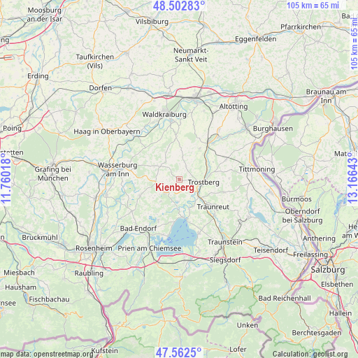
Kienberg GPS coordinates[2]
48° 2' 5.316" North, 12° 27' 47.88" East
| Map corner | latitude | longitude |
|---|---|---|
| Upper-left | 48.50283°, | 11.76018° |
| Center: | 48.03481°, | 12.4633° |
| Lower-right: | 47.5625°, | 13.16643° |
| Map W x H: | 104.6×104.6 km | = 65×65mi |
| max Lat: | 55.01917° ⇑95.1% North |
| Kienberg: | 48.03481° |
| min Lat: | ⇓4.9% South 47.40724° |
| min Long | Kienberg | max Long |
| 5.92978° | 12.4633° | 14.98853° |
| W 87.6%⇐ | ⇒12.4% E |
Elevation
Elevation of Kienberg is 550 m = 1804 ft, and this is 300.9 m = 987 ft above average elevation for this country.
| Max E: |
1256 m = 4121 ft | 7.5% |
| Kienberg | 550 m 1804 ft | |
| Avg. | 249.1 m = 817 ft | |
Min E: |
-5 m = -16 ft | 92.5% |
See also: Germany elevation on elevation.city.
Geographical zone
Kienberg is located in North temperate zone (between Tropic of Cancer and the Arctic Circle). Distance of this North polar circle is 2060.2 km =1280.1 mi to North.| Distance of | km | miles | from Kienberg |
|---|---|---|---|
| North Pole | 4666.1 | 2899.4 | to North |
| Arctic Circle | 2060.2 | 1280.1 | to North |
| Tropic Cancer | 2735.1 | 1699.5 | to South |
| Equator | 5341 | 3318.7 | to South |


Nearby cities:
15 places around Kienberg: (largest is in red/bold)
• Amerang
12.5 km =7.8 mi,  247°
247°
• Eggstätt
13.5 km =8.4 mi,  207°
207°
• Engelsberg
10.8 km =6.7 mi,  33°
33°
• Höslwang
13.4 km =8.3 mi,  227°
227°
• Obing
5.8 km =3.6 mi, 228°
• Palling
13.4 km =8.3 mi,  105°
105°
• Pittenhart
8.4 km =5.2 mi,  220°
220°
• Schnaitsee
8 km =5 mi,  296°
296°
• Schönberg
13.5 km =8.4 mi,  281°
281°
• Seeon-Seebruck
7.6 km =4.7 mi,  178°
178°
• Tacherting
9.3 km =5.8 mi,  58°
58°
• Taufkirchen
12.8 km =8 mi,  355°
355°
• Traunreut
12.5 km =7.8 mi,  129°
129°
• Trostberg an der Alz
7.1 km =4.4 mi,  96°
96°
• Unterreit
13.3 km =8.3 mi,  313°
313°
Sources, notices
• [Note1] Compared only with cities in Germany existing in our database
• [Src1] Map data: © OpenStreetMap contributors (CC-BY-SA)
• [Src2] Other city data from geonames.org with taken over terms of usage.
• [Src3] Geographical zone / Annual Mean Temperature by Robert A. Rohde @ Wikipedia
