Pähl geodata
Pähl (Bavaria) is a seat of a fourth-order administrative division; located in Germany in Europe/Berlin (GMT+2) time zone. With population of 2,377 people, there are 4582 cities with bigger population in this country. Compared to other cities in Germany, 96.7% of cities are located further ↑North; 69.7% of cities are located further ←West and 94.3% of cities have lower elevation than Pähl. Note1
Administrative division(s):
- Level 1: Bavaria
- Level 2: Upper Bavaria
- Level 3: Landkreis Weilheim-Schongau
- Level 4: Pähl


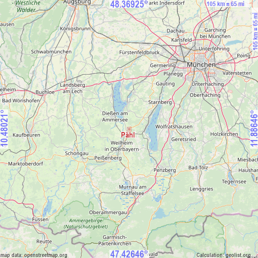
Pähl GPS coordinates[2]
47° 54' 0" North, 11° 10' 59.988" East
| Map corner | latitude | longitude |
|---|---|---|
| Upper-left | 48.36925°, | 10.48021° |
| Center: | 47.9°, | 11.18333° |
| Lower-right: | 47.42646°, | 11.88646° |
| Map W x H: | 104.8×104.8 km | = 65.1×65.1mi |
| max Lat: | 55.01917° ⇑96.7% North |
| Pähl: | 47.9° |
| min Lat: | ⇓3.3% South 47.40724° |
| min Long | Pähl | max Long |
| 5.92978° | 11.18333° | 14.98853° |
| W 69.7%⇐ | ⇒30.3% E |
Elevation
Elevation of Pähl is 582 m = 1909 ft, and this is 332.9 m = 1092 ft above average elevation for this country.
| Max E: |
1256 m = 4121 ft | 5.7% |
| Pähl | 582 m 1909 ft | |
| Avg. | 249.1 m = 817 ft | |
Min E: |
-5 m = -16 ft | 94.3% |
See also: Germany elevation on elevation.city.
Geographical zone
Pähl is located in North temperate zone (between Tropic of Cancer and the Arctic Circle). Distance of this North polar circle is 2075.2 km =1289.5 mi to North.| Distance of | km | miles | from Pähl |
|---|---|---|---|
| North Pole | 4681.1 | 2908.7 | to North |
| Arctic Circle | 2075.2 | 1289.5 | to North |
| Tropic Cancer | 2720.1 | 1690.2 | to South |
| Equator | 5326 | 3309.4 | to South |


Nearby cities:
15 places around Pähl: (largest is in red/bold)
• Andechs
8.3 km =5.2 mi,  359°
359°
• Bernried
9.1 km =5.7 mi,  114°
114°
• Dießen am Ammersee
8.2 km =5.1 mi,  313°
313°
• Feldafing
9.7 km =6 mi,  58°
58°
• Herrsching am Ammersee
11 km =6.8 mi, 357°
• Oberhausen
13.5 km =8.4 mi,  196°
196°
• Peißenberg
13.6 km =8.5 mi,  218°
218°
• Polling
10.6 km =6.6 mi, 201°
• Pöcking
11.4 km =7.1 mi,  49°
49°
• Raisting
6.5 km =4 mi,  286°
286°
• Seeshaupt
12.2 km =7.6 mi,  133°
133°
• Tutzing
7.3 km =4.5 mi,  81°
81°
• Weilheim
6.8 km =4.2 mi, 198°
• Wessobrunn
12.2 km =7.6 mi,  256°
256°
• Wielenbach
3.4 km =2.1 mi,  211°
211°
Sources, notices
• [Note1] Compared only with cities in Germany existing in our database
• [Src1] Map data: © OpenStreetMap contributors (CC-BY-SA)
• [Src2] Other city data from geonames.org with taken over terms of usage.
• [Src3] Geographical zone / Annual Mean Temperature by Robert A. Rohde @ Wikipedia
