Wielenbach geodata
Wielenbach (Bavaria) is a seat of a fourth-order administrative division; located in Germany in Europe/Berlin (GMT+2) time zone. In our database, there are 11009 cities with bigger population. Compared to other cities in Germany, 96.9% of cities are located further ↑North; 69.3% of cities are located further ←West and 92.8% of cities have lower elevation than Wielenbach. Note1
Administrative division(s):
- Level 1: Bavaria
- Level 2: Upper Bavaria
- Level 3: Landkreis Weilheim-Schongau
- Level 4: Wielenbach


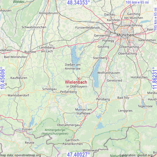
Wielenbach GPS coordinates[2]
47° 52' 26.58" North, 11° 9' 33.048" East
| Map corner | latitude | longitude |
|---|---|---|
| Upper-left | 48.34353°, | 10.45606° |
| Center: | 47.87405°, | 11.15918° |
| Lower-right: | 47.40027°, | 11.86231° |
| Map W x H: | 104.9×104.9 km | = 65.2×65.2mi |
| max Lat: | 55.01917° ⇑96.9% North |
| Wielenbach: | 47.87405° |
| min Lat: | ⇓3.1% South 47.40724° |
| min Long | Wielenbach | max Long |
| 5.92978° | 11.15918° | 14.98853° |
| W 69.3%⇐ | ⇒30.7% E |
Elevation
Elevation of Wielenbach is 555 m = 1821 ft, and this is 305.9 m = 1004 ft above average elevation for this country.
| Max E: |
1256 m = 4121 ft | 7.2% |
| Wielenbach | 555 m 1821 ft | |
| Avg. | 249.1 m = 817 ft | |
Min E: |
-5 m = -16 ft | 92.8% |
See also: Germany elevation on elevation.city.
Geographical zone
Wielenbach is located in North temperate zone (between Tropic of Cancer and the Arctic Circle). Distance of this North polar circle is 2078.1 km =1291.3 mi to North.| Distance of | km | miles | from Wielenbach |
|---|---|---|---|
| North Pole | 4684 | 2910.5 | to North |
| Arctic Circle | 2078.1 | 1291.3 | to North |
| Tropic Cancer | 2717.2 | 1688.4 | to South |
| Equator | 5323.1 | 3307.6 | to South |


Nearby cities:
15 places around Wielenbach: (largest is in red/bold)
• Andechs
11.3 km =7 mi,  8°
8°
• Bernried
10.1 km =6.3 mi,  95°
95°
• Dießen am Ammersee
9.5 km =5.9 mi,  333°
333°
• Feldafing
12.8 km =8 mi,  51°
51°
• Herrsching am Ammersee
13.9 km =8.6 mi, 5°
• Huglfing
12 km =7.5 mi,  177°
177°
• Oberhausen
10.3 km =6.4 mi,  190°
190°
• Peißenberg
10.2 km =6.3 mi,  220°
220°
• Polling
7.3 km =4.5 mi,  195°
195°
• Pähl
3.4 km =2.1 mi,  31°
31°
• Raisting
6.5 km =4 mi,  317°
317°
• Seeshaupt
12 km =7.5 mi,  117°
117°
• Tutzing
9.8 km =6.1 mi,  66°
66°
• Weilheim
3.6 km =2.2 mi, 185°
• Wessobrunn
10 km =6.2 mi,  270°
270°
Sources, notices
• [Note1] Compared only with cities in Germany existing in our database
• [Src1] Map data: © OpenStreetMap contributors (CC-BY-SA)
• [Src2] Other city data from geonames.org with taken over terms of usage.
• [Src3] Geographical zone / Annual Mean Temperature by Robert A. Rohde @ Wikipedia
