Ostseebad Boltenhagen geodata
Ostseebad Boltenhagen (Mecklenburg-Vorpommern) is a populated place; located in Germany in Europe/Berlin (GMT+2) time zone. With population of 2,574 people, there are 4357 cities with bigger population in this country. Compared to other cities in Germany, 92.5% of cities are located further ↓South; 70% of cities are located further ←West and 98.1% of cities have higher elevation than Ostseebad Boltenhagen. Note1
Administrative division(s):
- Level 1: Mecklenburg-Vorpommern
- Level 3: Nordwestmecklenburg
- Level 4: Boltenhagen


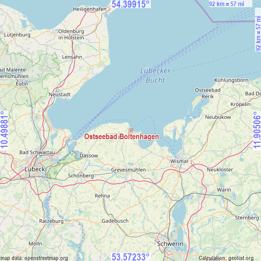
Ostseebad Boltenhagen GPS coordinates[2]
53° 59' 16.044" North, 11° 12' 6.948" East
| Map corner | latitude | longitude |
|---|---|---|
| Upper-left | 54.39915°, | 10.49881° |
| Center: | 53.98779°, | 11.20193° |
| Lower-right: | 53.57233°, | 11.90506° |
| Map W x H: | 91.9×91.9 km | = 57.1×57.1mi |
| max Lat: | 55.01917° ⇑7.5% North |
| Ostseebad Boltenhagen: | 53.98779° |
| min Lat: | ⇓92.5% South 47.40724° |
| min Long | Ostseebad Bolte | max Long |
| 5.92978° | 11.20193° | 14.98853° |
| W 70%⇐ | ⇒30% E |
Elevation
Elevation of Ostseebad Boltenhagen is 2 m = 7 ft, and this is 247.1 m = 811 ft below average elevation for this country.
| Max E: |
1256 m = 4121 ft | 98.1% |
| Avg. | 249.1 m = 817 ft | |
| Ostseebad Boltenhagen | 2 m = 7 ft | |
Min E: |
-5 m = -16 ft | 1.9% |
See also: Germany elevation on elevation.city.
Geographical zone
Ostseebad Boltenhagen is located in North temperate zone (between Tropic of Cancer and the Arctic Circle). Distance of this North polar circle is 1398.3 km =868.9 mi to North.| Distance of | km | miles | from Ostseebad Boltenhagen |
|---|---|---|---|
| North Pole | 4004.2 | 2488.1 | to North |
| Arctic Circle | 1398.3 | 868.9 | to North |
| Tropic Cancer | 3397 | 2110.8 | to South |
| Equator | 6002.9 | 3730 | to South |


Nearby cities:
15 places around Ostseebad Boltenhagen: (largest is in red/bold)
• Barnekow
17.5 km =10.9 mi,  140°
140°
• Börzow
15.1 km =9.4 mi,  199°
199°
• Damshagen
7.3 km =4.5 mi,  205°
205°
• Dassow
17.1 km =10.6 mi,  240°
240°
• Elmenhorst
5.1 km =3.2 mi,  276°
276°
• Gramkow
10.6 km =6.6 mi,  134°
134°
• Grevesmühlen
13.9 km =8.6 mi,  182°
182°
• Kalkhorst
10.5 km =6.5 mi,  259°
259°
• Klütz
3.6 km =2.2 mi,  224°
224°
• Mallentin
14.4 km =8.9 mi, 214°
• Plüschow
17.5 km =10.9 mi,  165°
165°
• Pötenitz
18.7 km =11.6 mi, 256°
• Upahl
18.6 km =11.6 mi, 177°
• Weitendorf
14.3 km =8.9 mi, 135°
• Zierow
13.3 km =8.3 mi,  121°
121°
Sources, notices
• [Note1] Compared only with cities in Germany existing in our database
• [Src1] Map data: © OpenStreetMap contributors (CC-BY-SA)
• [Src2] Other city data from geonames.org with taken over terms of usage.
• [Src3] Geographical zone / Annual Mean Temperature by Robert A. Rohde @ Wikipedia
