Plüschow geodata
Plüschow (Mecklenburg-Vorpommern) is a populated place; located in Germany in Europe/Berlin (GMT+2) time zone. With population of 541 people, there are 9136 cities with bigger population in this country. Compared to other cities in Germany, 90.5% of cities are located further ↓South; 70.9% of cities are located further ←West and 84.5% of cities have higher elevation than Plüschow. Note1
Administrative division(s):
- Level 1: Mecklenburg-Vorpommern
- Level 3: Nordwestmecklenburg
- Level 4: Upahl


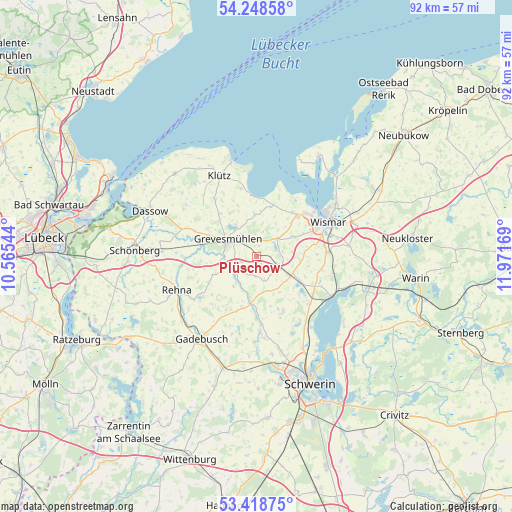
Plüschow GPS coordinates[2]
53° 50' 8.592" North, 11° 16' 6.816" East
| Map corner | latitude | longitude |
|---|---|---|
| Upper-left | 54.24858°, | 10.56544° |
| Center: | 53.83572°, | 11.26856° |
| Lower-right: | 53.41875°, | 11.97169° |
| Map W x H: | 92.3×92.3 km | = 57.4×57.4mi |
| max Lat: | 55.01917° ⇑9.5% North |
| Plüschow: | 53.83572° |
| min Lat: | ⇓90.5% South 47.40724° |
| min Long | Plüschow | max Long |
| 5.92978° | 11.26856° | 14.98853° |
| W 70.9%⇐ | ⇒29.1% E |
Elevation
Elevation of Plüschow is 36 m = 118 ft, and this is 213.1 m = 699 ft below average elevation for this country.
| Max E: |
1256 m = 4121 ft | 84.5% |
| Avg. | 249.1 m = 817 ft | |
| Plüschow | 36 m = 118 ft | |
Min E: |
-5 m = -16 ft | 15.5% |
See also: Germany elevation on elevation.city.
Geographical zone
Plüschow is located in North temperate zone (between Tropic of Cancer and the Arctic Circle). Distance of this North polar circle is 1415.2 km =879.4 mi to North.| Distance of | km | miles | from Plüschow |
|---|---|---|---|
| North Pole | 4021.1 | 2498.6 | to North |
| Arctic Circle | 1415.2 | 879.4 | to North |
| Tropic Cancer | 3380.1 | 2100.3 | to South |
| Equator | 5986 | 3719.5 | to South |


Nearby cities:
15 places around Plüschow: (largest is in red/bold)
• Alt Meteln
10.9 km =6.8 mi,  154°
154°
• Barnekow
7.6 km =4.7 mi,  63°
63°
• Beidendorf
7.9 km =4.9 mi,  96°
96°
• Bobitz
6.9 km =4.3 mi,  120°
120°
• Börzow
9.7 km =6 mi,  286°
286°
• Gramkow
10 km =6.2 mi,  18°
18°
• Grevesmühlen
5.9 km =3.7 mi,  301°
301°
• Groß Krankow
5 km =3.1 mi, 117°
• Groß Stieten
12.1 km =7.5 mi, 101°
• Mühlen Eichsen
8.8 km =5.5 mi,  187°
187°
• Rüting
5.6 km =3.5 mi,  214°
214°
• Testorf-Steinfort
6.6 km =4.1 mi,  179°
179°
• Upahl
3.8 km =2.4 mi,  243°
243°
• Veelböken
11.2 km =7 mi, 210°
• Weitendorf
8.7 km =5.4 mi,  40°
40°
Sources, notices
• [Note1] Compared only with cities in Germany existing in our database
• [Src1] Map data: © OpenStreetMap contributors (CC-BY-SA)
• [Src2] Other city data from geonames.org with taken over terms of usage.
• [Src3] Geographical zone / Annual Mean Temperature by Robert A. Rohde @ Wikipedia
