Klütz geodata
Klütz (Mecklenburg-Vorpommern) is a populated place; located in Germany in Europe/Berlin (GMT+2) time zone. With population of 3,229 people, there are 3807 cities with bigger population in this country. Compared to other cities in Germany, 92.2% of cities are located further ↓South; 69.3% of cities are located further ←West and 94.8% of cities have higher elevation than Klütz. Note1
Administrative division(s):
- Level 1: Mecklenburg-Vorpommern
- Level 3: Nordwestmecklenburg
- Level 4: Klütz


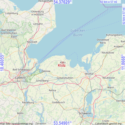
Klütz GPS coordinates[2]
53° 57' 52.92" North, 11° 9' 49.212" East
| Map corner | latitude | longitude |
|---|---|---|
| Upper-left | 54.37629°, | 10.46055° |
| Center: | 53.9647°, | 11.16367° |
| Lower-right: | 53.54901°, | 11.8668° |
| Map W x H: | 92×92 km | = 57.2×57.2mi |
| max Lat: | 55.01917° ⇑7.8% North |
| Klütz: | 53.9647° |
| min Lat: | ⇓92.2% South 47.40724° |
| min Long | Klütz | max Long |
| 5.92978° | 11.16367° | 14.98853° |
| W 69.3%⇐ | ⇒30.7% E |
Elevation
Elevation of Klütz is 9 m = 30 ft, and this is 240.1 m = 788 ft below average elevation for this country.
| Max E: |
1256 m = 4121 ft | 94.8% |
| Avg. | 249.1 m = 817 ft | |
| Klütz | 9 m = 30 ft | |
Min E: |
-5 m = -16 ft | 5.2% |
See also: Germany elevation on elevation.city.
Geographical zone
Klütz is located in North temperate zone (between Tropic of Cancer and the Arctic Circle). Distance of this North polar circle is 1400.9 km =870.5 mi to North.| Distance of | km | miles | from Klütz |
|---|---|---|---|
| North Pole | 4006.7 | 2489.6 | to North |
| Arctic Circle | 1400.9 | 870.5 | to North |
| Tropic Cancer | 3394.4 | 2109.2 | to South |
| Equator | 6000.3 | 3728.4 | to South |


Nearby cities:
15 places around Klütz: (largest is in red/bold)
• Barnekow
17.5 km =10.9 mi,  128°
128°
• Börzow
11.9 km =7.4 mi,  191°
191°
• Damshagen
4.1 km =2.5 mi, 189°
• Dassow
13.7 km =8.5 mi,  244°
244°
• Elmenhorst
4.1 km =2.5 mi,  320°
320°
• Gramkow
11.2 km =7 mi,  115°
115°
• Grevesmühlen
11.4 km =7.1 mi,  170°
170°
• Kalkhorst
7.8 km =4.8 mi,  274°
274°
• Mallentin
10.9 km =6.8 mi,  211°
211°
• Ostseebad Boltenhagen
3.6 km =2.2 mi,  44°
44°
• Plüschow
15.9 km =9.9 mi,  154°
154°
• Pötenitz
15.8 km =9.8 mi,  263°
263°
• Upahl
16.4 km =10.2 mi, 167°
• Weitendorf
14.6 km =9.1 mi, 121°
• Zierow
14.6 km =9.1 mi,  107°
107°
Sources, notices
• [Note1] Compared only with cities in Germany existing in our database
• [Src1] Map data: © OpenStreetMap contributors (CC-BY-SA)
• [Src2] Other city data from geonames.org with taken over terms of usage.
• [Src3] Geographical zone / Annual Mean Temperature by Robert A. Rohde @ Wikipedia
