Kalkhorst geodata
Kalkhorst (Mecklenburg-Vorpommern) is a populated place; located in Germany in Europe/Berlin (GMT+2) time zone. With population of 1,328 people, there are 6226 cities with bigger population in this country. Compared to other cities in Germany, 92.3% of cities are located further ↓South; 67.6% of cities are located further ←West and 86.6% of cities have higher elevation than Kalkhorst. Note1
Administrative division(s):
- Level 1: Mecklenburg-Vorpommern
- Level 3: Nordwestmecklenburg
- Level 4: Kalkhorst


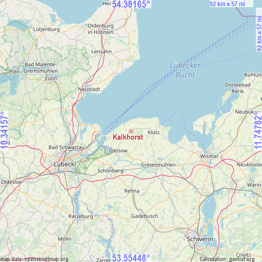
Kalkhorst GPS coordinates[2]
53° 58' 12.432" North, 11° 2' 40.884" East
| Map corner | latitude | longitude |
|---|---|---|
| Upper-left | 54.38165°, | 10.34157° |
| Center: | 53.97012°, | 11.04469° |
| Lower-right: | 53.55448°, | 11.74782° |
| Map W x H: | 92×92 km | = 57.2×57.2mi |
| max Lat: | 55.01917° ⇑7.7% North |
| Kalkhorst: | 53.97012° |
| min Lat: | ⇓92.3% South 47.40724° |
| min Long | Kalkhorst | max Long |
| 5.92978° | 11.04469° | 14.98853° |
| W 67.6%⇐ | ⇒32.4% E |
Elevation
Elevation of Kalkhorst is 31 m = 102 ft, and this is 218.1 m = 716 ft below average elevation for this country.
| Max E: |
1256 m = 4121 ft | 86.6% |
| Avg. | 249.1 m = 817 ft | |
| Kalkhorst | 31 m = 102 ft | |
Min E: |
-5 m = -16 ft | 13.4% |
See also: Germany elevation on elevation.city.
Geographical zone
Kalkhorst is located in North temperate zone (between Tropic of Cancer and the Arctic Circle). Distance of this North polar circle is 1400.3 km =870.1 mi to North.| Distance of | km | miles | from Kalkhorst |
|---|---|---|---|
| North Pole | 4006.1 | 2489.3 | to North |
| Arctic Circle | 1400.3 | 870.1 | to North |
| Tropic Cancer | 3395 | 2109.6 | to South |
| Equator | 6000.9 | 3728.8 | to South |


Nearby cities:
15 places around Kalkhorst: (largest is in red/bold)
• Börzow
13.4 km =8.3 mi,  156°
156°
• Damshagen
8.5 km =5.3 mi,  122°
122°
• Dassow
8 km =5 mi,  214°
214°
• Elmenhorst
5.8 km =3.6 mi,  63°
63°
• Gramkow
18.7 km =11.6 mi,  107°
107°
• Grevesmühlen
15.3 km =9.5 mi,  140°
140°
• Klütz
7.8 km =4.8 mi,  94°
94°
• Mallentin
10 km =6.2 mi,  168°
168°
• Ostseebad Boltenhagen
10.5 km =6.5 mi,  79°
79°
• Pötenitz
8.2 km =5.1 mi,  253°
253°
• Ratekau
20.5 km =12.7 mi,  263°
263°
• Selmsdorf
15.5 km =9.6 mi,  231°
231°
• Timmendorfer Strand
17.7 km =11 mi,  279°
279°
• Travemünde
11.4 km =7.1 mi,  266°
266°
• Upahl
20.1 km =12.5 mi,  145°
145°
Sources, notices
• [Note1] Compared only with cities in Germany existing in our database
• [Src1] Map data: © OpenStreetMap contributors (CC-BY-SA)
• [Src2] Other city data from geonames.org with taken over terms of usage.
• [Src3] Geographical zone / Annual Mean Temperature by Robert A. Rohde @ Wikipedia
