Osthofen geodata
Osthofen (Rheinland-Pfalz) is a populated place; located in Germany in Europe/Berlin (GMT+2) time zone. With population of 8,758 people, there are 1831 cities with bigger population in this country. Compared to other cities in Germany, 71.3% of cities are located further ↑North; 72.7% of cities are located further →East and 68.7% of cities have higher elevation than Osthofen. Note1
Administrative division(s):
- Level 1: Rheinland-Pfalz
- Level 3: Landkreis Alzey-Worms
- Level 4: Osthofen


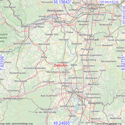
Osthofen GPS coordinates[2]
49° 42' 13.752" North, 8° 19' 27.084" East
| Map corner | latitude | longitude |
|---|---|---|
| Upper-left | 50.15643°, | 7.62106° |
| Center: | 49.70382°, | 8.32419° |
| Lower-right: | 49.24695°, | 9.02731° |
| Map W x H: | 101.1×101.1 km | = 62.8×62.8mi |
| max Lat: | 55.01917° ⇑71.3% North |
| Osthofen: | 49.70382° |
| min Lat: | ⇓28.7% South 47.40724° |
| min Long | Osthofen | max Long |
| 5.92978° | 8.32419° | 14.98853° |
| W 27.3%⇐ | ⇒72.7% E |
Elevation
Elevation of Osthofen is 99 m = 325 ft, and this is 150.1 m = 492 ft below average elevation for this country.
| Max E: |
1256 m = 4121 ft | 68.7% |
| Avg. | 249.1 m = 817 ft | |
| Osthofen | 99 m = 325 ft | |
Min E: |
-5 m = -16 ft | 31.3% |
See also: Germany elevation on elevation.city.
Geographical zone
Osthofen is located in North temperate zone (between Tropic of Cancer and the Arctic Circle). Distance of this North polar circle is 1874.6 km =1164.8 mi to North.| Distance of | km | miles | from Osthofen |
|---|---|---|---|
| North Pole | 4480.5 | 2784.1 | to North |
| Arctic Circle | 1874.6 | 1164.8 | to North |
| Tropic Cancer | 2920.6 | 1814.8 | to South |
| Equator | 5526.5 | 3434 | to South |


Nearby cities:
15 places around Osthofen: (largest is in red/bold)
• Alsheim
7.2 km =4.5 mi,  9°
9°
• Bechtheim
3.5 km =2.2 mi,  319°
319°
• Bermersheim
7.6 km =4.7 mi,  251°
251°
• Dittelsheim-Heßloch
7.7 km =4.8 mi,  305°
305°
• Dorn-Dürkheim
8.2 km =5.1 mi,  331°
331°
• Eich
7.4 km =4.6 mi,  46°
46°
• Frettenheim
8.4 km =5.2 mi, 317°
• Gundersheim
8.8 km =5.5 mi,  264°
264°
• Gundheim
7 km =4.3 mi,  243°
243°
• Mettenheim
4 km =2.5 mi,  1°
1°
• Monzernheim
7.2 km =4.5 mi,  285°
285°
• Mörstadt
6.8 km =4.2 mi,  227°
227°
• Westhofen
5.5 km =3.4 mi,  270°
270°
• Wintersheim
8.9 km =5.5 mi,  339°
339°
• Worms
8.3 km =5.2 mi,  162°
162°
Sources, notices
• [Note1] Compared only with cities in Germany existing in our database
• [Src1] Map data: © OpenStreetMap contributors (CC-BY-SA)
• [Src2] Other city data from geonames.org with taken over terms of usage.
• [Src3] Geographical zone / Annual Mean Temperature by Robert A. Rohde @ Wikipedia
