Gutenzell-Hürbel geodata
Gutenzell-Hürbel (Baden-Württemberg) is a seat of a fourth-order administrative division; located in Germany in Europe/Berlin (GMT+2) time zone. With population of 1,922 people, there are 5179 cities with bigger population in this country. Compared to other cities in Germany, 93.9% of cities are located further ↑North; 50.3% of cities are located further →East and 93.8% of cities have lower elevation than Gutenzell-Hürbel. Note1
Administrative division(s):
- Level 1: Baden-Württemberg
- Level 2: Tübingen Region
- Level 3: Landkreis Biberach
- Level 4: Gutenzell-Hürbel


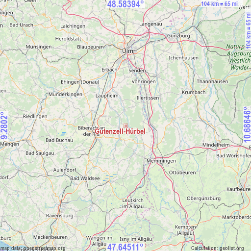
Gutenzell-Hürbel GPS coordinates[2]
48° 7' 0.012" North, 9° 58' 59.988" East
| Map corner | latitude | longitude |
|---|---|---|
| Upper-left | 48.58394°, | 9.2802° |
| Center: | 48.11667°, | 9.98333° |
| Lower-right: | 47.64511°, | 10.68646° |
| Map W x H: | 104.4×104.4 km | = 64.9×64.9mi |
| max Lat: | 55.01917° ⇑93.9% North |
| Gutenzell-Hürbel: | 48.11667° |
| min Lat: | ⇓6.1% South 47.40724° |
| min Long | Gutenzell-Hürb | max Long |
| 5.92978° | 9.98333° | 14.98853° |
| W 49.7%⇐ | ⇒50.3% E |
Elevation
Elevation of Gutenzell-Hürbel is 571 m = 1873 ft, and this is 321.9 m = 1056 ft above average elevation for this country.
| Max E: |
1256 m = 4121 ft | 6.2% |
| Gutenzell-Hürbel | 571 m 1873 ft | |
| Avg. | 249.1 m = 817 ft | |
Min E: |
-5 m = -16 ft | 93.8% |
See also: Germany elevation on elevation.city.
Geographical zone
Gutenzell-Hürbel is located in North temperate zone (between Tropic of Cancer and the Arctic Circle). Distance of this North polar circle is 2051.1 km =1274.5 mi to North.| Distance of | km | miles | from Gutenzell-Hürbel |
|---|---|---|---|
| North Pole | 4657 | 2893.7 | to North |
| Arctic Circle | 2051.1 | 1274.5 | to North |
| Tropic Cancer | 2744.2 | 1705.2 | to South |
| Equator | 5350.1 | 3324.4 | to South |


Nearby cities:
15 places around Gutenzell-Hürbel: (largest is in red/bold)
• Altenstadt
10.9 km =6.8 mi,  63°
63°
• Berkheim
11 km =6.8 mi,  138°
138°
• Dettingen an der Iller
10.1 km =6.3 mi,  100°
100°
• Erlenmoos
5.7 km =3.5 mi,  185°
185°
• Erolzheim
7.3 km =4.5 mi,  113°
113°
• Kellmünz
10.8 km =6.7 mi,  87°
87°
• Kirchberg an der Iller
7.6 km =4.7 mi,  75°
75°
• Kirchdorf
11.5 km =7.1 mi, 112°
• Maselheim
7.6 km =4.7 mi,  284°
284°
• Mietingen
9.7 km =6 mi,  320°
320°
• Ochsenhausen
5.7 km =3.5 mi,  205°
205°
• Rot an der Rot
12 km =7.5 mi,  163°
163°
• Schwendi
6.4 km =4 mi,  354°
354°
• Steinhausen an der Rottum
11.2 km =7 mi, 186°
• Wain
8.5 km =5.3 mi,  19°
19°
Sources, notices
• [Note1] Compared only with cities in Germany existing in our database
• [Src1] Map data: © OpenStreetMap contributors (CC-BY-SA)
• [Src2] Other city data from geonames.org with taken over terms of usage.
• [Src3] Geographical zone / Annual Mean Temperature by Robert A. Rohde @ Wikipedia
