Meuselbach geodata
Meuselbach (Thuringia) is a seat of a fourth-order administrative division; located in Germany in Europe/Berlin (GMT+2) time zone. With population of 1,373 people, there are 6131 cities with bigger population in this country. Compared to other cities in Germany, 51.2% of cities are located further ↑North; 68.3% of cities are located further ←West and 94.3% of cities have lower elevation than Meuselbach. Note1
Administrative division(s):
- Level 1: Thuringia
- Level 3: Saalfeld-Rudolstadt
- Level 4: Stadt Schwarzatal


Meuselbach GPS coordinates[2]
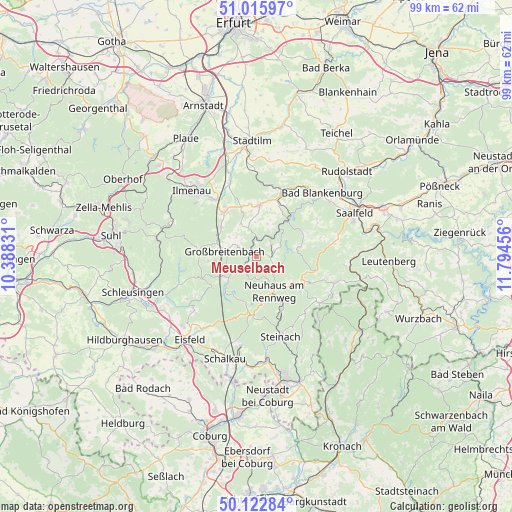
50° 34' 17.472" North, 11° 5' 29.148" East
| Map corner | latitude | longitude |
|---|---|---|
| Upper-left | 51.01597°, | 10.38831° |
| Center: | 50.57152°, | 11.09143° |
| Lower-right: | 50.12284°, | 11.79456° |
| Map W x H: | 99.3×99.3 km | = 61.7×61.7mi |
| max Lat: | 55.01917° ⇑51.2% North |
| Meuselbach: | 50.57152° |
| min Lat: | ⇓48.8% South 47.40724° |
| min Long | Meuselbach | max Long |
| 5.92978° | 11.09143° | 14.98853° |
| W 68.3%⇐ | ⇒31.7% E |
Elevation
Elevation of Meuselbach is 583 m = 1913 ft, and this is 333.9 m = 1095 ft above average elevation for this country.
| Max E: |
1256 m = 4121 ft | 5.7% |
| Meuselbach | 583 m 1913 ft | |
| Avg. | 249.1 m = 817 ft | |
Min E: |
-5 m = -16 ft | 94.3% |
See also: Germany elevation on elevation.city.
Geographical zone
Meuselbach is located in North temperate zone (between Tropic of Cancer and the Arctic Circle). Distance of this North polar circle is 1778.1 km =1104.9 mi to North.| Distance of | km | miles | from Meuselbach |
|---|---|---|---|
| North Pole | 4384 | 2724.1 | to North |
| Arctic Circle | 1778.1 | 1104.9 | to North |
| Tropic Cancer | 3017.1 | 1874.7 | to South |
| Equator | 5623 | 3494 | to South |


Nearby cities:
15 places around Meuselbach: (largest is in red/bold)
• Böhlen
3.9 km =2.4 mi,  298°
298°
• Cursdorf
3 km =1.9 mi,  100°
100°
• Deesbach
4.2 km =2.6 mi, 97°
• Dröbischau
6.6 km =4.1 mi,  348°
348°
• Friedersdorf
5.4 km =3.4 mi,  313°
313°
• Gillersdorf
7.3 km =4.5 mi, 313°
• Großbreitenbach
5.9 km =3.7 mi,  282°
282°
• Herschdorf
7.1 km =4.4 mi,  335°
335°
• Katzhütte
3.5 km =2.2 mi,  231°
231°
• Mellenbach-Glasbach
5.1 km =3.2 mi,  6°
6°
• Neuhaus am Rennweg
7.6 km =4.7 mi,  154°
154°
• Oberhain
7.5 km =4.7 mi,  23°
23°
• Oberweißbach
3.9 km =2.4 mi,  72°
72°
• Unterweißbach
7.1 km =4.4 mi,  48°
48°
• Wildenspring
3.6 km =2.2 mi,  331°
331°
Sources, notices
• [Note1] Compared only with cities in Germany existing in our database
• [Src1] Map data: © OpenStreetMap contributors (CC-BY-SA)
• [Src2] Other city data from geonames.org with taken over terms of usage.
• [Src3] Geographical zone / Annual Mean Temperature by Robert A. Rohde @ Wikipedia
