Böhlen geodata
Böhlen (Thuringia) is a seat of a fourth-order administrative division; located in Germany in Europe/Berlin (GMT+2) time zone. With population of 721 people, there are 8230 cities with bigger population in this country. Compared to other cities in Germany, 50.8% of cities are located further ↑North; 67.6% of cities are located further ←West and 95.3% of cities have lower elevation than Böhlen. Note1


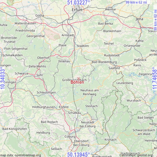
Böhlen GPS coordinates[2]
50° 35' 16.728" North, 11° 2' 36.42" East
| Map corner | latitude | longitude |
|---|---|---|
| Upper-left | 51.03227°, | 10.34033° |
| Center: | 50.58798°, | 11.04345° |
| Lower-right: | 50.13945°, | 11.74658° |
| Map W x H: | 99.3×99.3 km | = 61.7×61.7mi |
| max Lat: | 55.01917° ⇑50.8% North |
| Böhlen: | 50.58798° |
| min Lat: | ⇓49.2% South 47.40724° |
| min Long | Böhlen | max Long |
| 5.92978° | 11.04345° | 14.98853° |
| W 67.6%⇐ | ⇒32.4% E |
Elevation
Elevation of Böhlen is 607 m = 1991 ft, and this is 357.9 m = 1174 ft above average elevation for this country.
| Max E: |
1256 m = 4121 ft | 4.7% |
| Böhlen | 607 m 1991 ft | |
| Avg. | 249.1 m = 817 ft | |
Min E: |
-5 m = -16 ft | 95.3% |
See also: Germany elevation on elevation.city.
Geographical zone
Böhlen is located in North temperate zone (between Tropic of Cancer and the Arctic Circle). Distance of this North polar circle is 1776.3 km =1103.7 mi to North.| Distance of | km | miles | from Böhlen |
|---|---|---|---|
| North Pole | 4382.2 | 2723 | to North |
| Arctic Circle | 1776.3 | 1103.7 | to North |
| Tropic Cancer | 3018.9 | 1875.9 | to South |
| Equator | 5624.9 | 3495.1 | to South |


Nearby cities:
15 places around Böhlen: (largest is in red/bold)
• Altenfeld
5.9 km =3.7 mi,  246°
246°
• Cursdorf
6.8 km =4.2 mi,  110°
110°
• Dröbischau
5.1 km =3.2 mi,  24°
24°
• Friedersdorf
2 km =1.2 mi,  343°
343°
• Gehren
7.3 km =4.5 mi, 337°
• Gillersdorf
3.7 km =2.3 mi,  329°
329°
• Großbreitenbach
2.4 km =1.5 mi,  257°
257°
• Herschdorf
4.6 km =2.9 mi,  4°
4°
• Katzhütte
4.1 km =2.5 mi,  170°
170°
• Mellenbach-Glasbach
5.1 km =3.2 mi,  51°
51°
• Meuselbach
3.9 km =2.4 mi,  118°
118°
• Möhrenbach
5.2 km =3.2 mi,  319°
319°
• Neustadt am Rennsteig
7.8 km =4.8 mi,  266°
266°
• Oberweißbach
7.1 km =4.4 mi,  95°
95°
• Wildenspring
2.1 km =1.3 mi, 50°
Sources, notices
• [Note1] Compared only with cities in Germany existing in our database
• [Src1] Map data: © OpenStreetMap contributors (CC-BY-SA)
• [Src2] Other city data from geonames.org with taken over terms of usage.
• [Src3] Geographical zone / Annual Mean Temperature by Robert A. Rohde @ Wikipedia
