Alleshausen geodata
Alleshausen (Baden-Württemberg) is a seat of a fourth-order administrative division; located in Germany in Europe/Berlin (GMT+2) time zone. With population of 494 people, there are 9393 cities with bigger population in this country. Compared to other cities in Germany, 94% of cities are located further ↑North; 55.7% of cities are located further →East and 94.6% of cities have lower elevation than Alleshausen. Note1
Administrative division(s):
- Level 1: Baden-Württemberg
- Level 2: Tübingen Region
- Level 3: Landkreis Biberach
- Level 4: Alleshausen


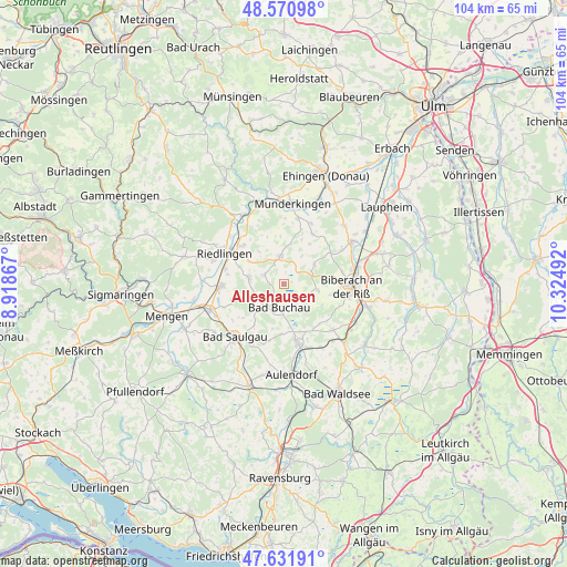
Alleshausen GPS coordinates[2]
48° 6' 12.924" North, 9° 37' 18.444" East
| Map corner | latitude | longitude |
|---|---|---|
| Upper-left | 48.57098°, | 8.91867° |
| Center: | 48.10359°, | 9.62179° |
| Lower-right: | 47.63191°, | 10.32492° |
| Map W x H: | 104.4×104.4 km | = 64.9×64.9mi |
| max Lat: | 55.01917° ⇑94% North |
| Alleshausen: | 48.10359° |
| min Lat: | ⇓6% South 47.40724° |
| min Long | Alleshausen | max Long |
| 5.92978° | 9.62179° | 14.98853° |
| W 44.3%⇐ | ⇒55.7% E |
Elevation
Elevation of Alleshausen is 589 m = 1932 ft, and this is 339.9 m = 1115 ft above average elevation for this country.
| Max E: |
1256 m = 4121 ft | 5.4% |
| Alleshausen | 589 m 1932 ft | |
| Avg. | 249.1 m = 817 ft | |
Min E: |
-5 m = -16 ft | 94.6% |
See also: Germany elevation on elevation.city.
Geographical zone
Alleshausen is located in North temperate zone (between Tropic of Cancer and the Arctic Circle). Distance of this North polar circle is 2052.6 km =1275.4 mi to North.| Distance of | km | miles | from Alleshausen |
|---|---|---|---|
| North Pole | 4658.4 | 2894.6 | to North |
| Arctic Circle | 2052.6 | 1275.4 | to North |
| Tropic Cancer | 2742.7 | 1704.2 | to South |
| Equator | 5348.6 | 3323.5 | to South |


Nearby cities:
15 places around Alleshausen: (largest is in red/bold)
• Allmannsweiler
8.6 km =5.3 mi,  194°
194°
• Attenweiler
6.7 km =4.2 mi,  60°
60°
• Bad Buchau
4.6 km =2.9 mi, 188°
• Betzenweiler
4.3 km =2.7 mi,  289°
289°
• Dürmentingen
6.7 km =4.2 mi,  282°
282°
• Dürnau
6.9 km =4.3 mi,  225°
225°
• Grundsheim
7.8 km =4.8 mi,  25°
25°
• Kanzach
5.5 km =3.4 mi,  238°
238°
• Mittelbiberach
9.8 km =6.1 mi,  103°
103°
• Oberstadion
10.6 km =6.6 mi, 29°
• Oggelshausen
4.6 km =2.9 mi,  152°
152°
• Seekirch
2.1 km =1.3 mi, 100°
• Tiefenbach
3.1 km =1.9 mi,  137°
137°
• Unlingen
10.2 km =6.3 mi,  313°
313°
• Uttenweiler
5.2 km =3.2 mi,  355°
355°
Sources, notices
• [Note1] Compared only with cities in Germany existing in our database
• [Src1] Map data: © OpenStreetMap contributors (CC-BY-SA)
• [Src2] Other city data from geonames.org with taken over terms of usage.
• [Src3] Geographical zone / Annual Mean Temperature by Robert A. Rohde @ Wikipedia
