Bobingen geodata
Bobingen (Bavaria) is a populated place; located in Germany in Europe/Berlin (GMT+2) time zone. With population of 16,682 people, there are 947 cities with bigger population in this country. Compared to other cities in Germany, 91.6% of cities are located further ↑North; 64.6% of cities are located further ←West and 90.6% of cities have lower elevation than Bobingen. Note1
Administrative division(s):
- Level 1: Bavaria
- Level 2: Swabia
- Level 3: Landkreis Augsburg
- Level 4: Bobingen


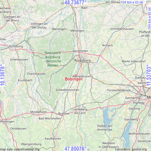
Bobingen GPS coordinates[2]
48° 16' 15.276" North, 10° 50' 2.04" East
| Map corner | latitude | longitude |
|---|---|---|
| Upper-left | 48.73677°, | 10.13078° |
| Center: | 48.27091°, | 10.8339° |
| Lower-right: | 47.80076°, | 11.53703° |
| Map W x H: | 104.1×104.1 km | = 64.7×64.7mi |
| max Lat: | 55.01917° ⇑91.6% North |
| Bobingen: | 48.27091° |
| min Lat: | ⇓8.4% South 47.40724° |
| min Long | Bobingen | max Long |
| 5.92978° | 10.8339° | 14.98853° |
| W 64.6%⇐ | ⇒35.4% E |
Elevation
Elevation of Bobingen is 521 m = 1709 ft, and this is 271.9 m = 892 ft above average elevation for this country.
| Max E: |
1256 m = 4121 ft | 9.4% |
| Bobingen | 521 m 1709 ft | |
| Avg. | 249.1 m = 817 ft | |
Min E: |
-5 m = -16 ft | 90.6% |
See also: Germany elevation on elevation.city.
Geographical zone
Bobingen is located in North temperate zone (between Tropic of Cancer and the Arctic Circle). Distance of this North polar circle is 2034 km =1263.9 mi to North.| Distance of | km | miles | from Bobingen |
|---|---|---|---|
| North Pole | 4639.8 | 2883 | to North |
| Arctic Circle | 2034 | 1263.9 | to North |
| Tropic Cancer | 2761.3 | 1715.8 | to South |
| Equator | 5367.2 | 3335 | to South |


Nearby cities:
15 places around Bobingen: (largest is in red/bold)
• Brunnen
11.3 km =7 mi,  114°
114°
• Diedorf
9.9 km =6.2 mi,  337°
337°
• Gessertshausen
9.9 km =6.2 mi,  310°
310°
• Graben
9.3 km =5.8 mi,  185°
185°
• Großaitingen
6.3 km =3.9 mi,  219°
219°
• Kissing
10.8 km =6.7 mi,  70°
70°
• Kleinaitingen
6.4 km =4 mi,  155°
155°
• Königsbrunn
4.3 km =2.7 mi,  83°
83°
• Merching
11.5 km =7.1 mi,  103°
103°
• Mering
11.2 km =7 mi,  93°
93°
• Oberottmarshausen
4.1 km =2.5 mi,  154°
154°
• Prittriching
10.5 km =6.5 mi,  138°
138°
• Schmiechen
11.5 km =7.1 mi,  121°
121°
• Stadtbergen
10.7 km =6.6 mi,  4°
4°
• Wehringen
3.4 km =2.1 mi,  227°
227°
Sources, notices
• [Note1] Compared only with cities in Germany existing in our database
• [Src1] Map data: © OpenStreetMap contributors (CC-BY-SA)
• [Src2] Other city data from geonames.org with taken over terms of usage.
• [Src3] Geographical zone / Annual Mean Temperature by Robert A. Rohde @ Wikipedia
