Stadthagen geodata
Stadthagen (Lower Saxony) is a seat of a third-order administrative division; located in Germany in Europe/Berlin (GMT+2) time zone. With population of 23,076 people, there are 645 cities with bigger population in this country. Compared to other cities in Germany, 75.4% of cities are located further ↓South; 62.3% of cities are located further →East and 72.1% of cities have higher elevation than Stadthagen. Note1


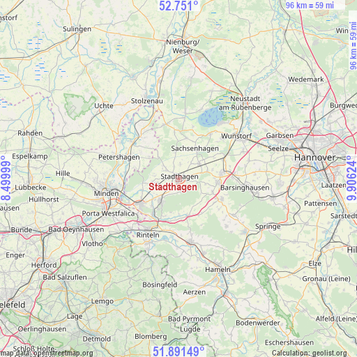
Stadthagen GPS coordinates[2]
52° 19' 23.988" North, 9° 12' 11.196" East
| Map corner | latitude | longitude |
|---|---|---|
| Upper-left | 52.751°, | 8.49999° |
| Center: | 52.32333°, | 9.20311° |
| Lower-right: | 51.89149°, | 9.90624° |
| Map W x H: | 95.6×95.6 km | = 59.4×59.4mi |
| max Lat: | 55.01917° ⇑24.6% North |
| Stadthagen: | 52.32333° |
| min Lat: | ⇓75.4% South 47.40724° |
| min Long | Stadthagen | max Long |
| 5.92978° | 9.20311° | 14.98853° |
| W 37.7%⇐ | ⇒62.3% E |
Elevation
Elevation of Stadthagen is 77 m = 253 ft, and this is 172.1 m = 565 ft below average elevation for this country.
| Max E: |
1256 m = 4121 ft | 72.1% |
| Avg. | 249.1 m = 817 ft | |
| Stadthagen | 77 m = 253 ft | |
Min E: |
-5 m = -16 ft | 27.9% |
See also: Germany elevation on elevation.city.
Geographical zone
Stadthagen is located in North temperate zone (between Tropic of Cancer and the Arctic Circle). Distance of this North polar circle is 1583.4 km =983.9 mi to North.| Distance of | km | miles | from Stadthagen |
|---|---|---|---|
| North Pole | 4189.3 | 2603.1 | to North |
| Arctic Circle | 1583.4 | 983.9 | to North |
| Tropic Cancer | 3211.9 | 1995.8 | to South |
| Equator | 5817.8 | 3615 | to South |


Nearby cities:
15 places around Stadthagen: (largest is in red/bold)
• Beckedorf
8.3 km =5.2 mi,  68°
68°
• Helpsen
6 km =3.7 mi,  257°
257°
• Hespe
6.5 km =4 mi,  276°
276°
• Heuerßen
5.1 km =3.2 mi,  82°
82°
• Lauenhagen
3.6 km =2.2 mi,  3°
3°
• Lindhorst
6.7 km =4.2 mi,  54°
54°
• Lüdersfeld
5.3 km =3.3 mi,  40°
40°
• Meerbeck
4.1 km =2.5 mi,  299°
299°
• Niedernwöhren
4.9 km =3 mi,  310°
310°
• Nienstädt
4.3 km =2.7 mi,  217°
217°
• Nordsehl
3.3 km =2.1 mi,  335°
335°
• Obernkirchen
7.6 km =4.7 mi, 221°
• Pollhagen
7 km =4.3 mi,  351°
351°
• Seggebruch
7.8 km =4.8 mi,  251°
251°
• Wiedensahl
8.8 km =5.5 mi,  320°
320°
Sources, notices
• [Note1] Compared only with cities in Germany existing in our database
• [Src1] Map data: © OpenStreetMap contributors (CC-BY-SA)
• [Src2] Other city data from geonames.org with taken over terms of usage.
• [Src3] Geographical zone / Annual Mean Temperature by Robert A. Rohde @ Wikipedia
