Oberneukirchen geodata
Oberneukirchen (Bavaria) is a seat of a fourth-order administrative division; located in Germany in Europe/Berlin (GMT+2) time zone. With population of 810 people, there are 7858 cities with bigger population in this country. Compared to other cities in Germany, 92.9% of cities are located further ↑North; 88.1% of cities are located further ←West and 83.4% of cities have lower elevation than Oberneukirchen. Note1
Administrative division(s):
- Level 1: Bavaria
- Level 2: Upper Bavaria
- Level 3: Landkreis Mühldorf am Inn
- Level 4: Oberneukirchen


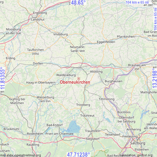
Oberneukirchen GPS coordinates[2]
48° 10' 59.988" North, 12° 31' 0.012" East
| Map corner | latitude | longitude |
|---|---|---|
| Upper-left | 48.65°, | 11.81355° |
| Center: | 48.18333°, | 12.51667° |
| Lower-right: | 47.71238°, | 13.2198° |
| Map W x H: | 104.3×104.3 km | = 64.8×64.8mi |
| max Lat: | 55.01917° ⇑92.9% North |
| Oberneukirchen: | 48.18333° |
| min Lat: | ⇓7.1% South 47.40724° |
| min Long | Oberneukirchen | max Long |
| 5.92978° | 12.51667° | 14.98853° |
| W 88.1%⇐ | ⇒11.9% E |
Elevation
Elevation of Oberneukirchen is 457 m = 1499 ft, and this is 207.9 m = 682 ft above average elevation for this country.
| Max E: |
1256 m = 4121 ft | 16.6% |
| Oberneukirchen | 457 m 1499 ft | |
| Avg. | 249.1 m = 817 ft | |
Min E: |
-5 m = -16 ft | 83.4% |
See also: Germany elevation on elevation.city.
Geographical zone
Oberneukirchen is located in North temperate zone (between Tropic of Cancer and the Arctic Circle). Distance of this North polar circle is 2043.7 km =1269.9 mi to North.| Distance of | km | miles | from Oberneukirchen |
|---|---|---|---|
| North Pole | 4649.6 | 2889.1 | to North |
| Arctic Circle | 2043.7 | 1269.9 | to North |
| Tropic Cancer | 2751.6 | 1709.8 | to South |
| Equator | 5357.5 | 3329 | to South |


Nearby cities:
15 places around Oberneukirchen: (largest is in red/bold)
• Ampfing
10.9 km =6.8 mi,  316°
316°
• Engelsberg
7.7 km =4.8 mi,  165°
165°
• Garching an der Alz
7.3 km =4.5 mi,  138°
138°
• Jettenbach
10.1 km =6.3 mi,  259°
259°
• Kraiburg am Inn
6.4 km =4 mi,  268°
268°
• Mettenheim
10 km =6.2 mi,  338°
338°
• Mühldorf
7.1 km =4.4 mi,  2°
2°
• Neufahrn
9.8 km =6.1 mi,  325°
325°
• Polling
5.2 km =3.2 mi,  44°
44°
• Taufkirchen
6.2 km =3.9 mi,  233°
233°
• Teising
8.5 km =5.3 mi,  55°
55°
• Töging am Inn
9.9 km =6.2 mi,  30°
30°
• Tüßling
6.9 km =4.3 mi, 62°
• Unterneukirchen
7.6 km =4.7 mi,  104°
104°
• Waldkraiburg
9.2 km =5.7 mi,  287°
287°
Sources, notices
• [Note1] Compared only with cities in Germany existing in our database
• [Src1] Map data: © OpenStreetMap contributors (CC-BY-SA)
• [Src2] Other city data from geonames.org with taken over terms of usage.
• [Src3] Geographical zone / Annual Mean Temperature by Robert A. Rohde @ Wikipedia
