Tüßling geodata
Tüßling (Bavaria) is a populated place; located in Germany in Europe/Berlin (GMT+2) time zone. With population of 3,240 people, there are 3796 cities with bigger population in this country. Compared to other cities in Germany, 92.5% of cities are located further ↑North; 88.8% of cities are located further ←West and 77% of cities have lower elevation than Tüßling. Note1
Administrative division(s):
- Level 1: Bavaria
- Level 2: Upper Bavaria
- Level 3: Landkreis Altötting
- Level 4: Tüßling, Markt


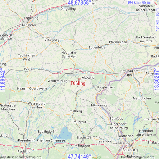
Tüßling GPS coordinates[2]
48° 12' 43.848" North, 12° 35' 58.344" East
| Map corner | latitude | longitude |
|---|---|---|
| Upper-left | 48.67858°, | 11.89642° |
| Center: | 48.21218°, | 12.59954° |
| Lower-right: | 47.74149°, | 13.30267° |
| Map W x H: | 104.2×104.2 km | = 64.7×64.7mi |
| max Lat: | 55.01917° ⇑92.5% North |
| Tüßling: | 48.21218° |
| min Lat: | ⇓7.5% South 47.40724° |
| min Long | Tüßling | max Long |
| 5.92978° | 12.59954° | 14.98853° |
| W 88.8%⇐ | ⇒11.2% E |
Elevation
Elevation of Tüßling is 412 m = 1352 ft, and this is 162.9 m = 534 ft above average elevation for this country.
| Max E: |
1256 m = 4121 ft | 23% |
| Tüßling | 412 m 1352 ft | |
| Avg. | 249.1 m = 817 ft | |
Min E: |
-5 m = -16 ft | 77% |
See also: Germany elevation on elevation.city.
Geographical zone
Tüßling is located in North temperate zone (between Tropic of Cancer and the Arctic Circle). Distance of this North polar circle is 2040.5 km =1267.9 mi to North.| Distance of | km | miles | from Tüßling |
|---|---|---|---|
| North Pole | 4646.4 | 2887.1 | to North |
| Arctic Circle | 2040.5 | 1267.9 | to North |
| Tropic Cancer | 2754.8 | 1711.8 | to South |
| Equator | 5360.7 | 3331 | to South |


Nearby cities:
15 places around Tüßling: (largest is in red/bold)
• Altötting
5.9 km =3.7 mi,  75°
75°
• Aresing
7.2 km =4.5 mi,  3°
3°
• Erharting
8 km =5 mi,  351°
351°
• Garching an der Alz
8.7 km =5.4 mi,  188°
188°
• Kastl
7.6 km =4.7 mi,  100°
100°
• Mühldorf
6.9 km =4.3 mi,  303°
303°
• Neuötting
7.4 km =4.6 mi,  64°
64°
• Oberneukirchen
6.9 km =4.3 mi,  242°
242°
• Pleiskirchen
10.6 km =6.6 mi,  359°
359°
• Polling
2.5 km =1.6 mi,  281°
281°
• Rohrbach
9.2 km =5.7 mi,  339°
339°
• Teising
1.9 km =1.2 mi,  27°
27°
• Töging am Inn
5.5 km =3.4 mi, 348°
• Unterneukirchen
5.2 km =3.2 mi,  165°
165°
• Winhöring
7.1 km =4.4 mi, 31°
Sources, notices
• [Note1] Compared only with cities in Germany existing in our database
• [Src1] Map data: © OpenStreetMap contributors (CC-BY-SA)
• [Src2] Other city data from geonames.org with taken over terms of usage.
• [Src3] Geographical zone / Annual Mean Temperature by Robert A. Rohde @ Wikipedia
