Oberheldrungen geodata
Oberheldrungen (Thuringia) is a seat of a fourth-order administrative division; located in Germany in Europe/Berlin (GMT+2) time zone. With population of 987 people, there are 7232 cities with bigger population in this country. Compared to other cities in Germany, 62.9% of cities are located further ↓South; 70.6% of cities are located further ←West and 60.1% of cities have higher elevation than Oberheldrungen. Note1


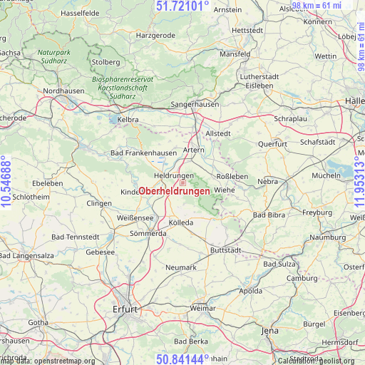
Oberheldrungen GPS coordinates[2]
51° 16' 59.988" North, 11° 15' 0" East
| Map corner | latitude | longitude |
|---|---|---|
| Upper-left | 51.72101°, | 10.54688° |
| Center: | 51.28333°, | 11.25° |
| Lower-right: | 50.84144°, | 11.95313° |
| Map W x H: | 97.8×97.8 km | = 60.8×60.8mi |
| max Lat: | 55.01917° ⇑37.1% North |
| Oberheldrungen: | 51.28333° |
| min Lat: | ⇓62.9% South 47.40724° |
| min Long | Oberheldrungen | max Long |
| 5.92978° | 11.25° | 14.98853° |
| W 70.6%⇐ | ⇒29.4% E |
Elevation
Elevation of Oberheldrungen is 151 m = 495 ft, and this is 98.1 m = 322 ft below average elevation for this country.
| Max E: |
1256 m = 4121 ft | 60.1% |
| Avg. | 249.1 m = 817 ft | |
| Oberheldrungen | 151 m = 495 ft | |
Min E: |
-5 m = -16 ft | 39.9% |
See also: Germany elevation on elevation.city.
Geographical zone
Oberheldrungen is located in North temperate zone (between Tropic of Cancer and the Arctic Circle). Distance of this North polar circle is 1699 km =1055.7 mi to North.| Distance of | km | miles | from Oberheldrungen |
|---|---|---|---|
| North Pole | 4304.9 | 2674.9 | to North |
| Arctic Circle | 1699 | 1055.7 | to North |
| Tropic Cancer | 3096.3 | 1924 | to South |
| Equator | 5702.2 | 3543.2 | to South |


Nearby cities:
15 places around Oberheldrungen: (largest is in red/bold)
• Beichlingen
5.7 km =3.5 mi,  174°
174°
• Bretleben
5.7 km =3.5 mi,  348°
348°
• Büchel
7.9 km =4.9 mi,  241°
241°
• Etzleben
6.1 km =3.8 mi,  252°
252°
• Gehofen
6.5 km =4 mi,  48°
48°
• Gorsleben
4.7 km =2.9 mi,  258°
258°
• Großmonra
8.4 km =5.2 mi,  157°
157°
• Hauteroda
3 km =1.9 mi,  128°
128°
• Heldrungen
3 km =1.9 mi,  313°
313°
• Hemleben
4.4 km =2.7 mi,  212°
212°
• Kannawurf
8.3 km =5.2 mi, 257°
• Nausitz
6.9 km =4.3 mi,  57°
57°
• Oldisleben
6.2 km =3.9 mi,  298°
298°
• Reinsdorf
5.7 km =3.5 mi,  11°
11°
• Schillingstedt
6.6 km =4.1 mi, 212°
Sources, notices
• [Note1] Compared only with cities in Germany existing in our database
• [Src1] Map data: © OpenStreetMap contributors (CC-BY-SA)
• [Src2] Other city data from geonames.org with taken over terms of usage.
• [Src3] Geographical zone / Annual Mean Temperature by Robert A. Rohde @ Wikipedia
