Oberems geodata
Oberems (Hesse) is a populated place; located in Germany in Europe/Berlin (GMT+2) time zone. With population of 700 people, there are 8312 cities with bigger population in this country. Compared to other cities in Germany, 58.2% of cities are located further ↑North; 71.9% of cities are located further →East and 77.7% of cities have lower elevation than Oberems. Note1
Administrative division(s):
- Level 1: Hesse
- Level 2: Regierungsbezirk Darmstadt
- Level 3: Hochtaunuskreis
- Level 4: Glashütten


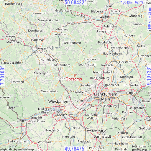
Oberems GPS coordinates[2]
50° 14' 11.796" North, 8° 24' 15.12" East
| Map corner | latitude | longitude |
|---|---|---|
| Upper-left | 50.68422°, | 7.70108° |
| Center: | 50.23661°, | 8.4042° |
| Lower-right: | 49.78475°, | 9.10733° |
| Map W x H: | 100×100 km | = 62.1×62.1mi |
| max Lat: | 55.01917° ⇑58.2% North |
| Oberems: | 50.23661° |
| min Lat: | ⇓41.8% South 47.40724° |
| min Long | Oberems | max Long |
| 5.92978° | 8.4042° | 14.98853° |
| W 28.1%⇐ | ⇒71.9% E |
Elevation
Elevation of Oberems is 417 m = 1368 ft, and this is 167.9 m = 551 ft above average elevation for this country.
| Max E: |
1256 m = 4121 ft | 22.3% |
| Oberems | 417 m 1368 ft | |
| Avg. | 249.1 m = 817 ft | |
Min E: |
-5 m = -16 ft | 77.7% |
See also: Germany elevation on elevation.city.
Geographical zone
Oberems is located in North temperate zone (between Tropic of Cancer and the Arctic Circle). Distance of this North polar circle is 1815.4 km =1128 mi to North.| Distance of | km | miles | from Oberems |
|---|---|---|---|
| North Pole | 4421.3 | 2747.3 | to North |
| Arctic Circle | 1815.4 | 1128 | to North |
| Tropic Cancer | 2979.9 | 1851.6 | to South |
| Equator | 5585.8 | 3470.9 | to South |


Nearby cities:
15 places around Oberems: (largest is in red/bold)
• Bad Camberg
11.7 km =7.3 mi,  304°
304°
• Bad Soden am Taunus
12.8 km =8 mi,  146°
146°
• Eppstein
10.5 km =6.5 mi,  184°
184°
• Glashütten
2.2 km =1.4 mi,  187°
187°
• Idstein
10 km =6.2 mi,  257°
257°
• Kelkheim (Taunus)
11.5 km =7.1 mi,  163°
163°
• Kronberg
10.3 km =6.4 mi,  124°
124°
• Kronberg Tal
9.5 km =5.9 mi,  131°
131°
• Königstein im Taunus
8 km =5 mi,  143°
143°
• Neu-Anspach
11.2 km =7 mi,  37°
37°
• Niedernhausen
10.4 km =6.5 mi,  218°
218°
• Oberursel
12.7 km =7.9 mi,  104°
104°
• Schmitten
4.7 km =2.9 mi, 44°
• Schwalbach am Taunus
13.3 km =8.3 mi, 136°
• Waldems
5.3 km =3.3 mi,  286°
286°
Sources, notices
• [Note1] Compared only with cities in Germany existing in our database
• [Src1] Map data: © OpenStreetMap contributors (CC-BY-SA)
• [Src2] Other city data from geonames.org with taken over terms of usage.
• [Src3] Geographical zone / Annual Mean Temperature by Robert A. Rohde @ Wikipedia
