Bad Camberg geodata
Bad Camberg (Hesse) is a populated place; located in Germany in Europe/Berlin (GMT+2) time zone. With population of 14,195 people, there are 1118 cities with bigger population in this country. Compared to other cities in Germany, 56.9% of cities are located further ↑North; 73.2% of cities are located further →East and 52.3% of cities have higher elevation than Bad Camberg. Note1
Administrative division(s):
- Level 1: Hesse
- Level 2: Regierungsbezirk Gießen
- Level 3: Landkreis Limburg-Weilburg
- Level 4: Bad Camberg


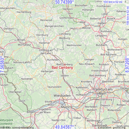
Bad Camberg GPS coordinates[2]
50° 17' 49.02" North, 8° 16' 8.256" East
| Map corner | latitude | longitude |
|---|---|---|
| Upper-left | 50.74399°, | 7.56583° |
| Center: | 50.29695°, | 8.26896° |
| Lower-right: | 49.84567°, | 8.97208° |
| Map W x H: | 99.9×99.9 km | = 62.1×62.1mi |
| max Lat: | 55.01917° ⇑56.9% North |
| Bad Camberg: | 50.29695° |
| min Lat: | ⇓43.1% South 47.40724° |
| min Long | Bad Camberg | max Long |
| 5.92978° | 8.26896° | 14.98853° |
| W 26.8%⇐ | ⇒73.2% E |
Elevation
Elevation of Bad Camberg is 209 m = 686 ft, and this is 40.1 m = 132 ft below average elevation for this country.
| Max E: |
1256 m = 4121 ft | 52.3% |
| Avg. | 249.1 m = 817 ft | |
| Bad Camberg | 209 m = 686 ft | |
Min E: |
-5 m = -16 ft | 47.7% |
See also: Germany elevation on elevation.city.
Geographical zone
Bad Camberg is located in North temperate zone (between Tropic of Cancer and the Arctic Circle). Distance of this North polar circle is 1808.7 km =1123.9 mi to North.| Distance of | km | miles | from Bad Camberg |
|---|---|---|---|
| North Pole | 4414.6 | 2743.1 | to North |
| Arctic Circle | 1808.7 | 1123.9 | to North |
| Tropic Cancer | 2986.6 | 1855.8 | to South |
| Equator | 5592.5 | 3475 | to South |


Nearby cities:
15 places around Bad Camberg: (largest is in red/bold)
• Burgschwalbach
13.3 km =8.3 mi,  263°
263°
• Glashütten
12.9 km =8 mi,  133°
133°
• Hahnstätten
14.4 km =8.9 mi,  271°
271°
• Idstein
8.8 km =5.5 mi,  181°
181°
• Kaltenholzhausen
12 km =7.5 mi, 271°
• Lohrheim
15.7 km =9.8 mi,  278°
278°
• Netzbach
12.2 km =7.6 mi, 280°
• Niedernhausen
15.2 km =9.4 mi,  168°
168°
• Oberems
11.7 km =7.3 mi,  124°
124°
• Oberneisen
14 km =8.7 mi, 283°
• Runkel
14.6 km =9.1 mi,  326°
326°
• Schiesheim
15.4 km =9.6 mi, 261°
• Schmitten
13.3 km =8.3 mi,  104°
104°
• Villmar
11.9 km =7.4 mi, 333°
• Waldems
6.9 km =4.3 mi,  138°
138°
Sources, notices
• [Note1] Compared only with cities in Germany existing in our database
• [Src1] Map data: © OpenStreetMap contributors (CC-BY-SA)
• [Src2] Other city data from geonames.org with taken over terms of usage.
• [Src3] Geographical zone / Annual Mean Temperature by Robert A. Rohde @ Wikipedia
