Schmitten geodata
Schmitten (Hesse) is a seat of a fourth-order administrative division; located in Germany in Europe/Berlin (GMT+2) time zone. With population of 9,042 people, there are 1777 cities with bigger population in this country. Compared to other cities in Germany, 57.5% of cities are located further ↑North; 71.5% of cities are located further →East and 84.5% of cities have lower elevation than Schmitten. Note1
Administrative division(s):
- Level 1: Hesse
- Level 2: Regierungsbezirk Darmstadt
- Level 3: Hochtaunuskreis
- Level 4: Schmitten


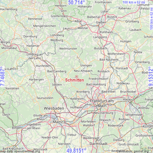
Schmitten GPS coordinates[2]
50° 16' 0.012" North, 8° 27' 0" East
| Map corner | latitude | longitude |
|---|---|---|
| Upper-left | 50.714°, | 7.74687° |
| Center: | 50.26667°, | 8.45° |
| Lower-right: | 49.8151°, | 9.15312° |
| Map W x H: | 99.9×99.9 km | = 62.1×62.1mi |
| max Lat: | 55.01917° ⇑57.5% North |
| Schmitten: | 50.26667° |
| min Lat: | ⇓42.5% South 47.40724° |
| min Long | Schmitten | max Long |
| 5.92978° | 8.45° | 14.98853° |
| W 28.5%⇐ | ⇒71.5% E |
Elevation
Elevation of Schmitten is 465 m = 1526 ft, and this is 215.9 m = 708 ft above average elevation for this country.
| Max E: |
1256 m = 4121 ft | 15.5% |
| Schmitten | 465 m 1526 ft | |
| Avg. | 249.1 m = 817 ft | |
Min E: |
-5 m = -16 ft | 84.5% |
See also: Germany elevation on elevation.city.
Geographical zone
Schmitten is located in North temperate zone (between Tropic of Cancer and the Arctic Circle). Distance of this North polar circle is 1812 km =1125.9 mi to North.| Distance of | km | miles | from Schmitten |
|---|---|---|---|
| North Pole | 4417.9 | 2745.2 | to North |
| Arctic Circle | 1812 | 1125.9 | to North |
| Tropic Cancer | 2983.2 | 1853.7 | to South |
| Equator | 5589.1 | 3472.9 | to South |


Nearby cities:
15 places around Schmitten: (largest is in red/bold)
• Bad Camberg
13.3 km =8.3 mi,  284°
284°
• Bad Homburg vor der Höhe
12.8 km =8 mi,  110°
110°
• Friedrichsdorf
13.8 km =8.6 mi,  97°
97°
• Glashütten
6.6 km =4.1 mi,  212°
212°
• Grävenwiesbach
13.7 km =8.5 mi,  2°
2°
• Kronberg
10.5 km =6.5 mi,  150°
150°
• Kronberg Tal
10.4 km =6.5 mi,  158°
158°
• Königstein im Taunus
9.8 km =6.1 mi,  171°
171°
• Neu-Anspach
6.6 km =4.1 mi,  32°
32°
• Oberems
4.7 km =2.9 mi,  224°
224°
• Oberursel
11.2 km =7 mi,  126°
126°
• Steinbach am Taunus
14 km =8.7 mi,  141°
141°
• Usingen
9.8 km =6.1 mi,  38°
38°
• Waldems
8.5 km =5.3 mi,  257°
257°
• Wehrheim
9.1 km =5.7 mi,  65°
65°
Sources, notices
• [Note1] Compared only with cities in Germany existing in our database
• [Src1] Map data: © OpenStreetMap contributors (CC-BY-SA)
• [Src2] Other city data from geonames.org with taken over terms of usage.
• [Src3] Geographical zone / Annual Mean Temperature by Robert A. Rohde @ Wikipedia
