Oberursel geodata
Oberursel (Hesse) is a populated place; located in Germany in Europe/Berlin (GMT+2) time zone. With population of 42,448 people, there are 294 cities with bigger population in this country. Compared to other cities in Germany, 58.9% of cities are located further ↑North; 70.4% of cities are located further →East and 51.3% of cities have higher elevation than Oberursel. Note1
Administrative division(s):
- Level 1: Hesse
- Level 2: Regierungsbezirk Darmstadt
- Level 3: Hochtaunuskreis
- Level 4: Oberursel (Taunus)


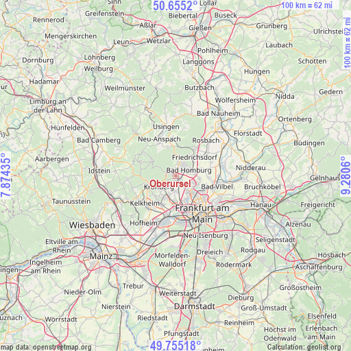
Oberursel GPS coordinates[2]
50° 12' 26.316" North, 8° 34' 38.892" East
| Map corner | latitude | longitude |
|---|---|---|
| Upper-left | 50.6552°, | 7.87435° |
| Center: | 50.20731°, | 8.57747° |
| Lower-right: | 49.75518°, | 9.2806° |
| Map W x H: | 100.1×100.1 km | = 62.2×62.2mi |
| max Lat: | 55.01917° ⇑58.9% North |
| Oberursel: | 50.20731° |
| min Lat: | ⇓41.1% South 47.40724° |
| min Long | Oberursel | max Long |
| 5.92978° | 8.57747° | 14.98853° |
| W 29.6%⇐ | ⇒70.4% E |
Elevation
Elevation of Oberursel is 216 m = 709 ft, and this is 33.1 m = 109 ft below average elevation for this country.
| Max E: |
1256 m = 4121 ft | 51.3% |
| Avg. | 249.1 m = 817 ft | |
| Oberursel | 216 m = 709 ft | |
Min E: |
-5 m = -16 ft | 48.7% |
See also: Oberursel elevation on elevation.city.
Geographical zone
Oberursel is located in North temperate zone (between Tropic of Cancer and the Arctic Circle). Distance of this North polar circle is 1818.6 km =1130 mi to North.| Distance of | km | miles | from Oberursel |
|---|---|---|---|
| North Pole | 4424.5 | 2749.3 | to North |
| Arctic Circle | 1818.6 | 1130 | to North |
| Tropic Cancer | 2976.6 | 1849.6 | to South |
| Equator | 5582.5 | 3468.8 | to South |


Nearby cities:
15 places around Oberursel: (largest is in red/bold)
• Bad Homburg vor der Höhe
3.6 km =2.2 mi,  53°
53°
• Bad Soden am Taunus
9 km =5.6 mi,  215°
215°
• Bad Vilbel
11.8 km =7.3 mi,  105°
105°
• Eschborn
7.1 km =4.4 mi,  183°
183°
• Friedrichsdorf
6.6 km =4.1 mi,  44°
44°
• Kelkheim (Taunus)
12 km =7.5 mi,  229°
229°
• Kronberg
4.6 km =2.9 mi,  236°
236°
• Kronberg Tal
6.1 km =3.8 mi, 239°
• Königstein im Taunus
8.2 km =5.1 mi,  247°
247°
• Liederbach
11.2 km =7 mi,  212°
212°
• Schmitten
11.2 km =7 mi,  306°
306°
• Schwalbach am Taunus
7.1 km =4.4 mi, 206°
• Steinbach am Taunus
4.4 km =2.7 mi, 184°
• Sulzbach
8.9 km =5.5 mi,  203°
203°
• Wehrheim
10.3 km =6.4 mi,  355°
355°
Sources, notices
• [Note1] Compared only with cities in Germany existing in our database
• [Src1] Map data: © OpenStreetMap contributors (CC-BY-SA)
• [Src2] Other city data from geonames.org with taken over terms of usage.
• [Src3] Geographical zone / Annual Mean Temperature by Robert A. Rohde @ Wikipedia
