Kronberg geodata
Kronberg (Hesse) is a populated place; located in Germany in Europe/Berlin (GMT+2) time zone. With population of 17,730 people, there are 898 cities with bigger population in this country. Compared to other cities in Germany, 59.2% of cities are located further ↑North; 70.9% of cities are located further →East and 53.9% of cities have lower elevation than Kronberg. Note1
Administrative division(s):
- Level 1: Hesse
- Level 2: Regierungsbezirk Darmstadt
- Level 3: Hochtaunuskreis
- Level 4: Kronberg im Taunus


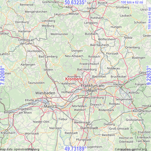
Kronberg GPS coordinates[2]
50° 11' 3.264" North, 8° 31' 23.52" East
| Map corner | latitude | longitude |
|---|---|---|
| Upper-left | 50.63235°, | 7.82008° |
| Center: | 50.18424°, | 8.5232° |
| Lower-right: | 49.73189°, | 9.22633° |
| Map W x H: | 100.1×100.1 km | = 62.2×62.2mi |
| max Lat: | 55.01917° ⇑59.2% North |
| Kronberg: | 50.18424° |
| min Lat: | ⇓40.8% South 47.40724° |
| min Long | Kronberg | max Long |
| 5.92978° | 8.5232° | 14.98853° |
| W 29.1%⇐ | ⇒70.9% E |
Elevation
Elevation of Kronberg is 251 m = 823 ft, and this is 1.9 m = 6 ft above average elevation for this country.
| Max E: |
1256 m = 4121 ft | 46.1% |
| Kronberg | 251 m 823 ft | |
| Avg. | 249.1 m = 817 ft | |
Min E: |
-5 m = -16 ft | 53.9% |
See also: Germany elevation on elevation.city.
Geographical zone
Kronberg is located in North temperate zone (between Tropic of Cancer and the Arctic Circle). Distance of this North polar circle is 1821.2 km =1131.6 mi to North.| Distance of | km | miles | from Kronberg |
|---|---|---|---|
| North Pole | 4427.1 | 2750.9 | to North |
| Arctic Circle | 1821.2 | 1131.6 | to North |
| Tropic Cancer | 2974 | 1848 | to South |
| Equator | 5580 | 3467.3 | to South |


Nearby cities:
15 places around Kronberg: (largest is in red/bold)
• Bad Homburg vor der Höhe
8.3 km =5.2 mi,  54°
54°
• Bad Soden am Taunus
5 km =3.1 mi,  195°
195°
• Eppstein
10.4 km =6.5 mi,  243°
243°
• Eschborn
5.7 km =3.5 mi,  143°
143°
• Glashütten
9.5 km =5.9 mi,  292°
292°
• Kelkheim (Taunus)
7.4 km =4.6 mi,  224°
224°
• Kronberg Tal
1.5 km =0.9 mi,  248°
248°
• Königstein im Taunus
3.7 km =2.3 mi,  261°
261°
• Liederbach
7.2 km =4.5 mi, 196°
• Oberems
10.3 km =6.4 mi,  304°
304°
• Oberursel
4.6 km =2.9 mi,  56°
56°
• Schmitten
10.5 km =6.5 mi,  330°
330°
• Schwalbach am Taunus
3.9 km =2.4 mi,  169°
169°
• Steinbach am Taunus
4 km =2.5 mi,  117°
117°
• Sulzbach
5.6 km =3.5 mi,  176°
176°
Sources, notices
• [Note1] Compared only with cities in Germany existing in our database
• [Src1] Map data: © OpenStreetMap contributors (CC-BY-SA)
• [Src2] Other city data from geonames.org with taken over terms of usage.
• [Src3] Geographical zone / Annual Mean Temperature by Robert A. Rohde @ Wikipedia
