Northeim geodata
Northeim (Lower Saxony) is a seat of a third-order administrative division; located in Germany in Europe/Berlin (GMT+2) time zone. With population of 30,894 people, there are 450 cities with bigger population in this country. Compared to other cities in Germany, 68.9% of cities are located further ↓South; 50% of cities are located further ←West and 63.9% of cities have higher elevation than Northeim. Note1


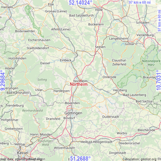
Northeim GPS coordinates[2]
51° 42' 23.832" North, 9° 59' 59.892" East
| Map corner | latitude | longitude |
|---|---|---|
| Upper-left | 52.14024°, | 9.29684° |
| Center: | 51.70662°, | 9.99997° |
| Lower-right: | 51.2688°, | 10.7031° |
| Map W x H: | 96.9×96.9 km | = 60.2×60.2mi |
| max Lat: | 55.01917° ⇑31.1% North |
| Northeim: | 51.70662° |
| min Lat: | ⇓68.9% South 47.40724° |
| min Long | Northeim | max Long |
| 5.92978° | 9.99997° | 14.98853° |
| W 50%⇐ | ⇒50% E |
Elevation
Elevation of Northeim is 127 m = 417 ft, and this is 122.1 m = 401 ft below average elevation for this country.
| Max E: |
1256 m = 4121 ft | 63.9% |
| Avg. | 249.1 m = 817 ft | |
| Northeim | 127 m = 417 ft | |
Min E: |
-5 m = -16 ft | 36.1% |
See also: Germany elevation on elevation.city.
Geographical zone
Northeim is located in North temperate zone (between Tropic of Cancer and the Arctic Circle). Distance of this North polar circle is 1651.9 km =1026.4 mi to North.| Distance of | km | miles | from Northeim |
|---|---|---|---|
| North Pole | 4257.8 | 2645.7 | to North |
| Arctic Circle | 1651.9 | 1026.4 | to North |
| Tropic Cancer | 3143.3 | 1953.2 | to South |
| Equator | 5749.2 | 3572.4 | to South |


Nearby cities:
15 places around Northeim: (largest is in red/bold)
• Badenhausen
15.8 km =9.8 mi,  63°
63°
• Bilshausen
13.9 km =8.6 mi,  128°
128°
• Bodensee
14.4 km =8.9 mi,  140°
140°
• Bovenden
14.2 km =8.8 mi,  202°
202°
• Einbeck
15.5 km =9.6 mi,  324°
324°
• Eisdorf am Harz
13.6 km =8.5 mi, 63°
• Gittelde
16.5 km =10.3 mi,  51°
51°
• Hardegsen
13.2 km =8.2 mi,  242°
242°
• Hillerse
4.2 km =2.6 mi, 235°
• Kalefeld
10.6 km =6.6 mi,  12°
12°
• Katlenburg-Lindau
7.4 km =4.6 mi,  110°
110°
• Krebeck
15.9 km =9.9 mi,  149°
149°
• Moringen
8.9 km =5.5 mi,  264°
264°
• Nörten-Hardenberg
9.7 km =6 mi,  207°
207°
• Wulften
13.1 km =8.1 mi, 113°
Sources, notices
• [Note1] Compared only with cities in Germany existing in our database
• [Src1] Map data: © OpenStreetMap contributors (CC-BY-SA)
• [Src2] Other city data from geonames.org with taken over terms of usage.
• [Src3] Geographical zone / Annual Mean Temperature by Robert A. Rohde @ Wikipedia
