Einbeck geodata
Einbeck (Lower Saxony) is a populated place; located in Germany in Europe/Berlin (GMT+2) time zone. With population of 27,931 people, there are 508 cities with bigger population in this country. Compared to other cities in Germany, 70.2% of cities are located further ↓South; 51.9% of cities are located further →East and 65.8% of cities have higher elevation than Einbeck. Note1


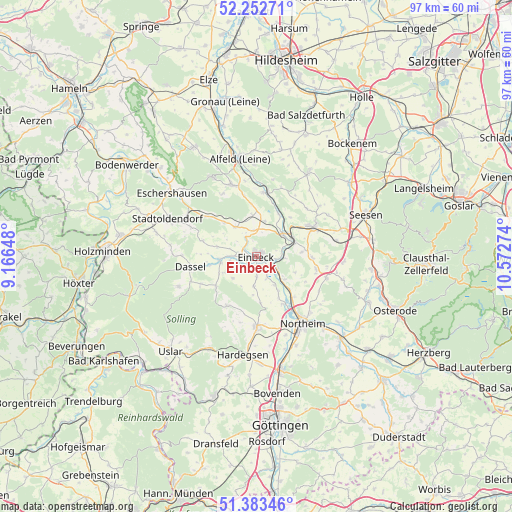
Einbeck GPS coordinates[2]
51° 49' 12.648" North, 9° 52' 10.596" East
| Map corner | latitude | longitude |
|---|---|---|
| Upper-left | 52.25271°, | 9.16648° |
| Center: | 51.82018°, | 9.86961° |
| Lower-right: | 51.38346°, | 10.57274° |
| Map W x H: | 96.7×96.7 km | = 60.1×60.1mi |
| max Lat: | 55.01917° ⇑29.8% North |
| Einbeck: | 51.82018° |
| min Lat: | ⇓70.2% South 47.40724° |
| min Long | Einbeck | max Long |
| 5.92978° | 9.86961° | 14.98853° |
| W 48.1%⇐ | ⇒51.9% E |
Elevation
Elevation of Einbeck is 115 m = 377 ft, and this is 134.1 m = 440 ft below average elevation for this country.
| Max E: |
1256 m = 4121 ft | 65.8% |
| Avg. | 249.1 m = 817 ft | |
| Einbeck | 115 m = 377 ft | |
Min E: |
-5 m = -16 ft | 34.2% |
See also: Germany elevation on elevation.city.
Geographical zone
Einbeck is located in North temperate zone (between Tropic of Cancer and the Arctic Circle). Distance of this North polar circle is 1639.3 km =1018.6 mi to North.| Distance of | km | miles | from Einbeck |
|---|---|---|---|
| North Pole | 4245.2 | 2637.8 | to North |
| Arctic Circle | 1639.3 | 1018.6 | to North |
| Tropic Cancer | 3155.9 | 1961 | to South |
| Equator | 5761.9 | 3580.3 | to South |


Nearby cities:
15 places around Einbeck: (largest is in red/bold)
• Bad Gandersheim
12.1 km =7.5 mi,  61°
61°
• Dassel
12.6 km =7.8 mi,  260°
260°
• Delligsen
14.2 km =8.8 mi,  341°
341°
• Eimen
9.2 km =5.7 mi,  319°
319°
• Everode
14.8 km =9.2 mi,  12°
12°
• Freden
12.1 km =7.5 mi, 7°
• Heinade
16.3 km =10.1 mi,  275°
275°
• Hillerse
15.9 km =9.9 mi,  159°
159°
• Kalefeld
11.5 km =7.1 mi,  101°
101°
• Kreiensen
7.5 km =4.7 mi, 60°
• Lenne
15.2 km =9.4 mi,  302°
302°
• Moringen
13.5 km =8.4 mi,  179°
179°
• Northeim
15.5 km =9.6 mi,  144°
144°
• Wangelnstedt
13.8 km =8.6 mi,  291°
291°
• Winzenburg
13.3 km =8.3 mi,  19°
19°
Sources, notices
• [Note1] Compared only with cities in Germany existing in our database
• [Src1] Map data: © OpenStreetMap contributors (CC-BY-SA)
• [Src2] Other city data from geonames.org with taken over terms of usage.
• [Src3] Geographical zone / Annual Mean Temperature by Robert A. Rohde @ Wikipedia
