Hillerse geodata
Hillerse (Lower Saxony) is a populated place; located in Germany in Europe/Berlin (GMT+2) time zone. With population of 2,663 people, there are 4266 cities with bigger population in this country. Compared to other cities in Germany, 68.8% of cities are located further ↓South; 50.8% of cities are located further →East and 61.9% of cities have higher elevation than Hillerse. Note1


Hillerse GPS coordinates[2]
51° 41' 8.088" North, 9° 56' 59.028" East
| Map corner | latitude | longitude |
|---|---|---|
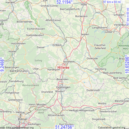
| Upper-left | 52.1194°, | 9.2466° |
| Center: | 51.68558°, | 9.94973° |
| Lower-right: | 51.24756°, | 10.65286° |
| Map W x H: | 96.9×96.9 km | = 60.2×60.2mi |
| max Lat: | 55.01917° ⇑31.2% North |
| Hillerse: | 51.68558° |
| min Lat: | ⇓68.8% South 47.40724° |
| min Long | Hillerse | max Long |
| 5.92978° | 9.94973° | 14.98853° |
| W 49.2%⇐ | ⇒50.8% E |
Elevation
Elevation of Hillerse is 139 m = 456 ft, and this is 110.1 m = 361 ft below average elevation for this country.
| Max E: |
1256 m = 4121 ft | 61.9% |
| Avg. | 249.1 m = 817 ft | |
| Hillerse | 139 m = 456 ft | |
Min E: |
-5 m = -16 ft | 38.1% |
See also: Germany elevation on elevation.city.
Geographical zone
Hillerse is located in North temperate zone (between Tropic of Cancer and the Arctic Circle). Distance of this North polar circle is 1654.3 km =1027.9 mi to North.| Distance of | km | miles | from Hillerse |
|---|---|---|---|
| North Pole | 4260.2 | 2647.2 | to North |
| Arctic Circle | 1654.3 | 1027.9 | to North |
| Tropic Cancer | 3141 | 1951.7 | to South |
| Equator | 5746.9 | 3571 | to South |


Nearby cities:
15 places around Hillerse: (largest is in red/bold)
• Bilshausen
15.7 km =9.8 mi,  113°
113°
• Bodensee
15.4 km =9.6 mi,  124°
124°
• Bovenden
11 km =6.8 mi,  189°
189°
• Ebergötzen
16.7 km =10.4 mi,  139°
139°
• Einbeck
15.9 km =9.9 mi,  339°
339°
• Göttingen
16.8 km =10.4 mi,  184°
184°
• Hardegsen
9 km =5.6 mi,  245°
245°
• Kalefeld
14 km =8.7 mi,  24°
24°
• Katlenburg-Lindau
10.4 km =6.5 mi,  91°
91°
• Krebeck
16.2 km =10.1 mi,  134°
134°
• Moringen
5.6 km =3.5 mi,  285°
285°
• Northeim
4.2 km =2.6 mi,  55°
55°
• Nörten-Hardenberg
6.4 km =4 mi, 188°
• Waake
16.2 km =10.1 mi,  152°
152°
• Wulften
15.7 km =9.8 mi,  100°
100°
Sources, notices
• [Note1] Compared only with cities in Germany existing in our database
• [Src1] Map data: © OpenStreetMap contributors (CC-BY-SA)
• [Src2] Other city data from geonames.org with taken over terms of usage.
• [Src3] Geographical zone / Annual Mean Temperature by Robert A. Rohde @ Wikipedia
