Norderney geodata
Norderney (Lower Saxony) is a populated place; located in Germany in Europe/Berlin (GMT+2) time zone. With population of 5,949 people, there are 2476 cities with bigger population in this country. Compared to other cities in Germany, 88.7% of cities are located further ↓South; 91.8% of cities are located further →East and 97% of cities have higher elevation than Norderney. Note1


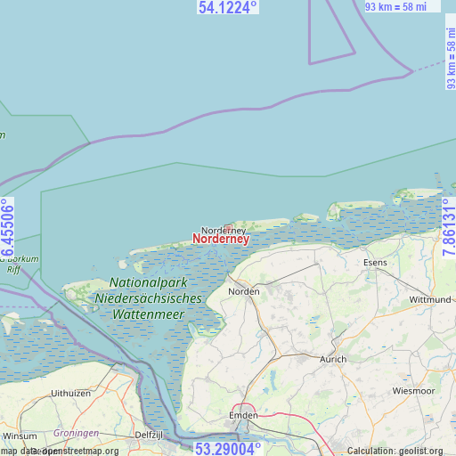
Norderney GPS coordinates[2]
53° 42' 29.808" North, 7° 9' 29.484" East
| Map corner | latitude | longitude |
|---|---|---|
| Upper-left | 54.1224°, | 6.45506° |
| Center: | 53.70828°, | 7.15819° |
| Lower-right: | 53.29004°, | 7.86131° |
| Map W x H: | 92.5×92.5 km | = 57.5×57.5mi |
| max Lat: | 55.01917° ⇑11.3% North |
| Norderney: | 53.70828° |
| min Lat: | ⇓88.7% South 47.40724° |
| min Long | Norderney | max Long |
| 5.92978° | 7.15819° | 14.98853° |
| W 8.2%⇐ | ⇒91.8% E |
Elevation
Elevation of Norderney is 4 m = 13 ft, and this is 245.1 m = 804 ft below average elevation for this country.
| Max E: |
1256 m = 4121 ft | 97% |
| Avg. | 249.1 m = 817 ft | |
| Norderney | 4 m = 13 ft | |
Min E: |
-5 m = -16 ft | 3% |
See also: Germany elevation on elevation.city.
Geographical zone
Norderney is located in North temperate zone (between Tropic of Cancer and the Arctic Circle). Distance of this North polar circle is 1429.4 km =888.2 mi to North.| Distance of | km | miles | from Norderney |
|---|---|---|---|
| North Pole | 4035.3 | 2507.4 | to North |
| Arctic Circle | 1429.4 | 888.2 | to North |
| Tropic Cancer | 3365.9 | 2091.5 | to South |
| Equator | 5971.8 | 3710.7 | to South |


Nearby cities:
15 places around Norderney: (largest is in red/bold)
• Baltrum
14.2 km =8.8 mi,  80°
80°
• Berumbur
15.9 km =9.9 mi,  139°
139°
• Dornum
19.1 km =11.9 mi,  111°
111°
• Hage
14.4 km =8.9 mi, 144°
• Hagermarsch
11.4 km =7.1 mi,  124°
124°
• Halbemond
18 km =11.2 mi,  150°
150°
• Juist
11.2 km =7 mi,  252°
252°
• Langeoog
21.9 km =13.6 mi, 77°
• Leezdorf
19.9 km =12.4 mi, 152°
• Lütetsburg
13.5 km =8.4 mi, 153°
• Marienhafe
22 km =13.7 mi,  159°
159°
• Norddeich
10.5 km =6.5 mi,  179°
179°
• Norden
12.9 km =8 mi,  165°
165°
• Osteel
19.3 km =12 mi, 160°
• Rechtsupweg
22.6 km =14 mi, 149°
Sources, notices
• [Note1] Compared only with cities in Germany existing in our database
• [Src1] Map data: © OpenStreetMap contributors (CC-BY-SA)
• [Src2] Other city data from geonames.org with taken over terms of usage.
• [Src3] Geographical zone / Annual Mean Temperature by Robert A. Rohde @ Wikipedia
