Langeoog geodata
Langeoog (Lower Saxony) is a seat of a fourth-order administrative division; located in Germany in Europe/Berlin (GMT+2) time zone. With population of 1,990 people, there are 5085 cities with bigger population in this country. Compared to other cities in Germany, 89.3% of cities are located further ↓South; 87.4% of cities are located further →East and 97.6% of cities have higher elevation than Langeoog. Note1


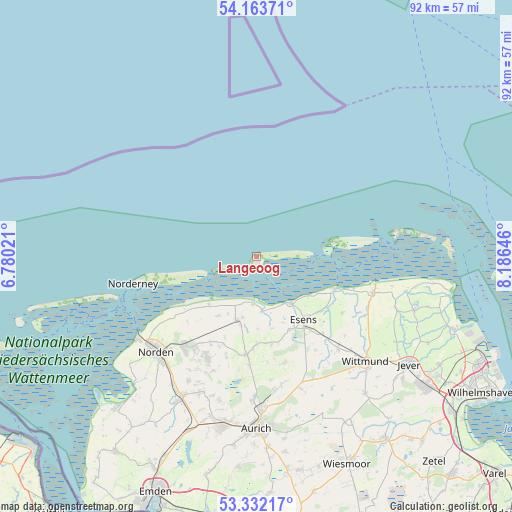
Langeoog GPS coordinates[2]
53° 45' 0" North, 7° 28' 59.988" East
| Map corner | latitude | longitude |
|---|---|---|
| Upper-left | 54.16371°, | 6.78021° |
| Center: | 53.75°, | 7.48333° |
| Lower-right: | 53.33217°, | 8.18646° |
| Map W x H: | 92.5×92.5 km | = 57.5×57.5mi |
| max Lat: | 55.01917° ⇑10.7% North |
| Langeoog: | 53.75° |
| min Lat: | ⇓89.3% South 47.40724° |
| min Long | Langeoog | max Long |
| 5.92978° | 7.48333° | 14.98853° |
| W 12.6%⇐ | ⇒87.4% E |
Elevation
Elevation of Langeoog is 3 m = 10 ft, and this is 246.1 m = 807 ft below average elevation for this country.
| Max E: |
1256 m = 4121 ft | 97.6% |
| Avg. | 249.1 m = 817 ft | |
| Langeoog | 3 m = 10 ft | |
Min E: |
-5 m = -16 ft | 2.4% |
See also: Germany elevation on elevation.city.
Geographical zone
Langeoog is located in North temperate zone (between Tropic of Cancer and the Arctic Circle). Distance of this North polar circle is 1424.7 km =885.3 mi to North.| Distance of | km | miles | from Langeoog |
|---|---|---|---|
| North Pole | 4030.6 | 2504.5 | to North |
| Arctic Circle | 1424.7 | 885.3 | to North |
| Tropic Cancer | 3370.5 | 2094.3 | to South |
| Equator | 5976.4 | 3713.6 | to South |


Nearby cities:
15 places around Langeoog: (largest is in red/bold)
• Baltrum
7.7 km =4.8 mi,  251°
251°
• Bensersiel
10.6 km =6.6 mi,  143°
143°
• Dornum
12 km =7.5 mi,  197°
197°
• Esens
14.1 km =8.8 mi, 142°
• Hagermarsch
16.4 km =10.2 mi,  227°
227°
• Holtgast
14.7 km =9.1 mi,  155°
155°
• Moorweg
14.5 km =9 mi,  153°
153°
• Neuharlingersiel
15.5 km =9.6 mi,  111°
111°
• Ostochtersum
16.3 km =10.1 mi,  169°
169°
• Schweindorf
16.7 km =10.4 mi,  183°
183°
• Spiekeroog
14.1 km =8.8 mi,  80°
80°
• Stedesdorf
17.7 km =11 mi, 137°
• Utarp
14.8 km =9.2 mi, 180°
• Werdum
18.6 km =11.6 mi,  123°
123°
• Westerholt
16.8 km =10.4 mi,  187°
187°
Sources, notices
• [Note1] Compared only with cities in Germany existing in our database
• [Src1] Map data: © OpenStreetMap contributors (CC-BY-SA)
• [Src2] Other city data from geonames.org with taken over terms of usage.
• [Src3] Geographical zone / Annual Mean Temperature by Robert A. Rohde @ Wikipedia
