Nohfelden geodata
Nohfelden (Saarland) is a seat of a fourth-order administrative division; located in Germany in Europe/Berlin (GMT+2) time zone. With population of 10,687 people, there are 1548 cities with bigger population in this country. Compared to other cities in Germany, 74% of cities are located further ↑North; 92% of cities are located further →East and 69% of cities have lower elevation than Nohfelden. Note1


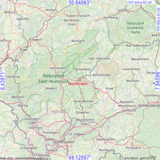
Nohfelden GPS coordinates[2]
49° 35' 12.948" North, 7° 8' 34.188" East
| Map corner | latitude | longitude |
|---|---|---|
| Upper-left | 50.04063°, | 6.43971° |
| Center: | 49.58693°, | 7.14283° |
| Lower-right: | 49.12897°, | 7.84596° |
| Map W x H: | 101.4×101.4 km | = 63×63mi |
| max Lat: | 55.01917° ⇑74% North |
| Nohfelden: | 49.58693° |
| min Lat: | ⇓26% South 47.40724° |
| min Long | Nohfelden | max Long |
| 5.92978° | 7.14283° | 14.98853° |
| W 8%⇐ | ⇒92% E |
Elevation
Elevation of Nohfelden is 351 m = 1152 ft, and this is 101.9 m = 334 ft above average elevation for this country.
| Max E: |
1256 m = 4121 ft | 31% |
| Nohfelden | 351 m 1152 ft | |
| Avg. | 249.1 m = 817 ft | |
Min E: |
-5 m = -16 ft | 69% |
See also: Germany elevation on elevation.city.
Geographical zone
Nohfelden is located in North temperate zone (between Tropic of Cancer and the Arctic Circle). Distance of this North polar circle is 1887.6 km =1172.9 mi to North.| Distance of | km | miles | from Nohfelden |
|---|---|---|---|
| North Pole | 4493.5 | 2792.1 | to North |
| Arctic Circle | 1887.6 | 1172.9 | to North |
| Tropic Cancer | 2907.6 | 1806.7 | to South |
| Equator | 5513.5 | 3425.9 | to South |


Nearby cities:
15 places around Nohfelden: (largest is in red/bold)
• Abentheuer
7.7 km =4.8 mi,  336°
336°
• Achtelsbach
5.7 km =3.5 mi,  318°
318°
• Birkenfeld
7.5 km =4.7 mi,  13°
13°
• Brücken
5.5 km =3.4 mi, 339°
• Dambach
5.2 km =3.2 mi,  352°
352°
• Dienstweiler
5.9 km =3.7 mi,  29°
29°
• Ellenberg
7 km =4.3 mi,  4°
4°
• Ellweiler
3.3 km =2.1 mi, 8°
• Gimbweiler
4.1 km =2.5 mi,  95°
95°
• Hahnweiler
5.8 km =3.6 mi,  112°
112°
• Hoppstädten-Weiersbach
5.3 km =3.3 mi,  51°
51°
• Leitzweiler
5.3 km =3.3 mi,  94°
94°
• Meckenbach
4.5 km =2.8 mi, 316°
• Namborn
7.3 km =4.5 mi,  181°
181°
• Rückweiler
6.5 km =4 mi, 93°
Sources, notices
• [Note1] Compared only with cities in Germany existing in our database
• [Src1] Map data: © OpenStreetMap contributors (CC-BY-SA)
• [Src2] Other city data from geonames.org with taken over terms of usage.
• [Src3] Geographical zone / Annual Mean Temperature by Robert A. Rohde @ Wikipedia
